
File:Karte Hochwasser in Deutschland Landkreise.png

Size of this preview: 569 × 599 pixels. Other resolutions: 228 × 240 pixels | 456 × 480 pixels | 729 × 768 pixels | 972 × 1,024 pixels | 1,325 × 1,396 pixels.
Original file (1,325 × 1,396 pixels, file size: 784 KB, MIME type: image/png)
Summary
| Description |
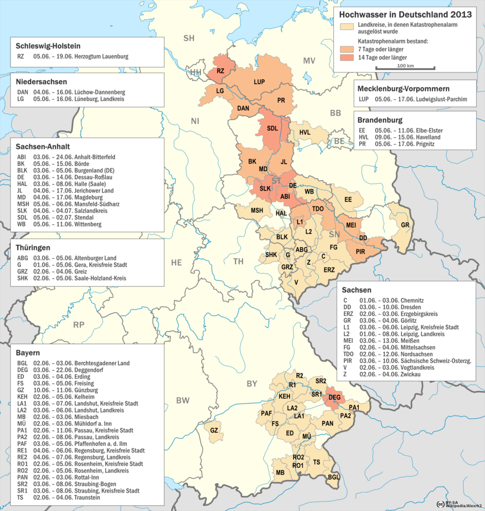
Deutsch: Karte zum Hochwasser in Deutschland von 2013 – Landkreise, in denen der Katastrophenalarm ausgelöst wurde. |
| Date | |
| Source |
Own work
|
| Author | Alexrk2 |
| Permission (Reusing this file) |
Für die Landkreise: © GeoBasis-DE / BKG 2013 (GeoNutzV) |

|
This map has been made or improved in the German Kartenwerkstatt (Map Lab). You can propose maps to improve as well.
|
Licensing
I, the copyright holder of this work, hereby publish it under the following license:
This file is licensed under the Creative Commons Attribution-Share Alike 3.0 Unported license.
- You are free:
- to share – to copy, distribute and transmit the work
- to remix – to adapt the work
- Under the following conditions:
- attribution – You must give appropriate credit, provide a link to the license, and indicate if changes were made. You may do so in any reasonable manner, but not in any way that suggests the licensor endorses you or your use.
- share alike – If you remix, transform, or build upon the material, you must distribute your contributions under the same or compatible license as the original.
References
Einzelnachweise für die Katastrophenalarmmeldungen der Landkreise:
File history
Click on a date/time to view the file as it appeared at that time.
| Date/Time | Thumbnail | Dimensions | User | Comment | |
|---|---|---|---|---|---|
| current | 16:08, 1 August 2013 | | 1,325 × 1,396 (784 KB) | Alexrk2 | + BGL |
| 15:24, 20 July 2013 |  | 1,325 × 1,396 (779 KB) | Alexrk2 | minor | |
| 15:05, 20 July 2013 |  | 1,349 × 1,421 (796 KB) | Alexrk2 | == {{int:filedesc}} == {{Information |Description= {{de|Karte zum Hochwasser in Deutschland von 2013 – Landkreise, in denen der Katastrophenalarm ausgelöst wurde.}} |Source={{own}} * Landkreise: [http://www.bkg.bund.de Bundesamt für Kartographie un... |
File usage
The following page uses this file:
Global file usage
The following other wikis use this file:
- Usage on de.wikipedia.org