
File:Lava wildfire at hawaii.jpg

Size of this preview: 800 × 513 pixels. Other resolutions: 320 × 205 pixels | 640 × 411 pixels | 1,024 × 657 pixels | 1,280 × 822 pixels | 2,200 × 1,412 pixels.
Original file (2,200 × 1,412 pixels, file size: 2.83 MB, MIME type: image/jpeg)
|
| Description |
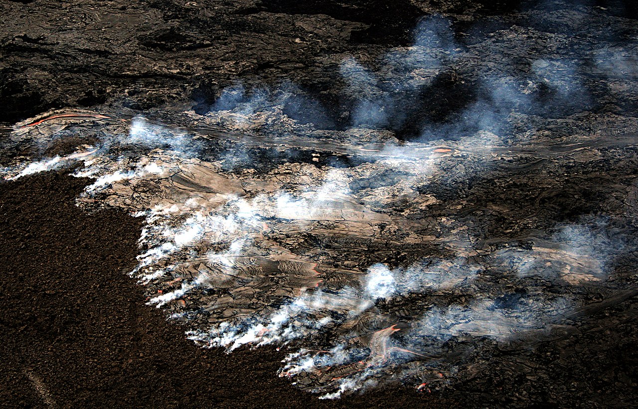
English: Pāhoehoe Lava flow on the coastal plain of Kīlauea, The Big Island of Hawai generated wildfire. The new lava is moving across the old surface, which is covered with a layer of moss about an inch thick. This moss is burning generating the smoke visible in the image. This kind of fire cannot be easily prevented or suppressed. The update that was written by USGS for the same day the image was taken - 09/04/07 says :"Lava flows advancing through vegetation are hazardous and can produce fire and methane explosions that propel chunks of lava and rock several feet into the air." The picture was taken from a helicopter.
Français : Une coulée de lave basaltique Pāhoehoe se répand sur la plaine côtière du Kīlauea, sur l'ile d'Hawaï, créant des feux. Cette nouvelle lave se répand sur une ancienne coulée couverte de mousse, qui s'enflamme, émettant la fumée visible sur la photo. Ce phénomène est dangereux car des explosions peuvent survenir, projetant des blocs de lave en fusion dans les airs. |
| Date | 09/04/07 |
| Source | Own work |
| Author | Brocken Inaglory |
| Camera location | | View this and other nearby images on: OpenStreetMap |
|---|
I, the copyright holder of this work, hereby publish it under the following licenses:
This file is licensed under the Creative Commons Attribution-Share Alike 3.0 Unported license.
- You are free:
- to share – to copy, distribute and transmit the work
- to remix – to adapt the work
- Under the following conditions:
- attribution – You must give appropriate credit, provide a link to the license, and indicate if changes were made. You may do so in any reasonable manner, but not in any way that suggests the licensor endorses you or your use.
- share alike – If you remix, transform, or build upon the material, you must distribute your contributions under the same or compatible license as the original.

|
Permission is granted to copy, distribute and/or modify this document under the terms of the GNU Free Documentation License, Version 1.2 or any later version published by the Free Software Foundation; with no Invariant Sections, no Front-Cover Texts, and no Back-Cover Texts. A copy of the license is included in the section entitled GNU Free Documentation License. |
You may select the license of your choice.
File history
Click on a date/time to view the file as it appeared at that time.
| Date/Time | Thumbnail | Dimensions | User | Comment | |
|---|---|---|---|---|---|
| current | 14:36, 18 May 2008 | | 2,200 × 1,412 (2.83 MB) | Mbz1 | {{Information |Description=[http://en.wikipedia.org/wiki/Lava#P.C4.81hoehoe Pāhoehoe Lava] flow on the coastal plain of [http://en.wikipedia.org/wiki/Kilauea Kīlauea], [http://en.wikipedia.org/wiki/Hawaii_(island) The Big Island of Hawai] generated [htt |
File usage
The following page uses this file:
Global file usage
The following other wikis use this file:
- Usage on ar.wikipedia.org
- Usage on dag.wikipedia.org
- Usage on de.wikipedia.org
- Usage on fr.wikipedia.org
- Usage on hi.wiktionary.org
- Usage on pl.wikipedia.org
- Usage on vi.wikipedia.org