
File:Railways in Benin.svg

Size of this PNG preview of this SVG file: 600 × 600 pixels. Other resolutions: 240 × 240 pixels | 480 × 480 pixels | 768 × 768 pixels | 1,024 × 1,024 pixels | 2,048 × 2,048 pixels.
Original file (SVG file, nominally 600 × 600 pixels, file size: 23 KB)
Summary
| Description |
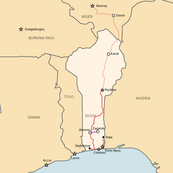
English: Map of railway network in Beninie
Legend: d03225 ee9c8d
Polski: Mapa sieci kolejowej w Beninie
Legenda:
|
| Date | |
| Source | http://sharemap.org/jkan/railway/Railways%20in%20Benin |
| Author | Jkan997 |
| SVG development | This W3C-invalid map was created with ShareMap.org. |
Thumbnail with colored legend in caption

existing 1000mm gauge, planned 1000mm gauge, dismantled 600mm gauge
[[File:Railways in Benin.svg|thumb|<center>Railways in Benin {{nowrap|([[ShareMap:jkan/railway/Railways_in_Benin|interactive version]])}}<br/><font color="#d03225">existing 1000mm gauge</font>, <font color="#ee9c8d">planned 1000mm gauge</font>, <font color="#CC00CC">dismantled 600mm gauge</font></center>]]
Licensing
I, the copyright holder of this work, hereby publish it under the following license:
This file is licensed under the Creative Commons Attribution 3.0 Unported license.
- You are free:
- to share – to copy, distribute and transmit the work
- to remix – to adapt the work
- Under the following conditions:
- attribution – You must give appropriate credit, provide a link to the license, and indicate if changes were made. You may do so in any reasonable manner, but not in any way that suggests the licensor endorses you or your use.
File history
Click on a date/time to view the file as it appeared at that time.
| Date/Time | Thumbnail | Dimensions | User | Comment | |
|---|---|---|---|---|---|
| current | 01:00, 26 November 2011 | | 600 × 600 (23 KB) | Jkan997 | added 600 mm tracks |
| 00:44, 26 November 2011 |  | 600 × 600 (22 KB) | Jkan997 | added planned line | |
| 14:05, 16 May 2011 |  | 200 × 250 (13 KB) | Jkan997 | {{Information |Description ={{en|1=Map of railway network in Beninie}} {{pl|1=Mapa sieci kolejowej w Beninie}} |Source =http://sharemap.org/jkan/railway/Railways in Benin |Author =Jkan997 |Date =2011-05-16 |Pe |
File usage
The following page uses this file:
Global file usage
The following other wikis use this file:
- Usage on de.wikipedia.org
- Usage on de.wikivoyage.org
- Usage on en.wikipedia.org
- Usage on eo.wikipedia.org
- Usage on es.wikipedia.org
- Usage on fr.wikipedia.org
- Usage on ha.wikipedia.org
- Usage on hu.wikipedia.org
- Usage on it.wikipedia.org
- Usage on it.wikivoyage.org
- Usage on ja.wikipedia.org
- Usage on no.wikipedia.org
- Usage on pl.wikipedia.org
- Usage on ru.wikipedia.org
- Usage on www.wikidata.org