
File:160316-031 Bridge near Tatopani.jpg

Size of this preview: 800 × 600 pixels. Other resolutions: 320 × 240 pixels | 640 × 480 pixels | 1,024 × 768 pixels | 1,280 × 960 pixels | 2,560 × 1,920 pixels | 4,608 × 3,456 pixels.
Original file (4,608 × 3,456 pixels, file size: 6.68 MB, MIME type: image/jpeg)
Summary
| Description |
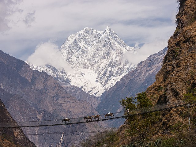
English: Nilgiri South (6,839m) forms an impressive backdrop to a large suspension bridge over the Kali Gandaki river near Tatopani.
ꯃꯤꯇꯩ ꯂꯣꯟ: ꯀꯥꯂꯤ ꯒꯟꯗꯛꯀꯤ ꯇꯨꯔꯦꯜ ꯃꯊꯛꯇ ꯁꯥꯕ ꯊꯣꯡ ꯑꯃꯅꯤ ꯫
Español: El Nilgiri Sur (6839 m) forma un impresionante telón de fondo para un puente colgante sobre el río Gandaki cerca de Tatopani.
Українська: Підвісний міст через річку Калі Ґандакі на фоні гори Нілгірі Південна (6839 м) поблизу Татопані, Непал. |
| Date | |
| Source | Own work |
| Author | Faj2323 |
| Other versions |
|

| Camera location | | View this and other nearby images on: OpenStreetMap |
|---|
Assessment
|
This image was selected as picture of the day on Wikimedia Commons for 24 January 2022. It was captioned as follows: English: Nilgiri South (6,839m) forms an impressive backdrop to a large suspension bridge over the Kali Gandaki river near Tatopani. Other languages:
Čeština: Hora Nilgiri South (6 839 m) vytváří výraznou dominantu nad velkým visutým mostem přes řeku Gandak poblíž vesnice Tatopani v Nepálu. English: Nilgiri South (6,839m) forms an impressive backdrop to a large suspension bridge over the Kali Gandaki river near Tatopani. Español: El Nilgiri Sur (6839 m) forma un impresionante telón de fondo para un puente colgante sobre el río Gandaki cerca de Tatopani. Français : Un pont suspendu au-dessus de la rivière Kali Gandaki au Népal. Derrière se dresse la montagne Nilgiri, faisant partie du massif de l'Annapurna. Italiano: Ponte sospeso sopra il fiume Gaṇḍakī, vicino Tatopani, in Nepal. Sullo sfondo il Nilgiri Sud (6,839 m). Magyar: A Kali Gandaki folyó felett átívelő függőhíd Tatopani közelében, hátterében a Nilgiri South (6839 m) (Nepál) Nederlands: Touwbrug over de Kali Gandaki, een zijrivier van de Ganges, in het Nepalese district Myagdi. Op de achtergrond de 6839 meter zuidtop van de Nilgiri in de Annapurna Himal. Português: Ponte suspensa sobre o rio Gandaki com o cenário do monte Nilgiri Sul (6 839m) ao fundo, perto de Tatopani, Nepal. Македонски: Висечки мост преку реката Кали Гандаки со планината Нилгири Југ (6.839 м) во позадина. Русский: Мост через реку Кали Гандаки в окрестностях деревни Татопани на фоне горы Нилгири Южная в Непале Українська: Підвісний міст через річку Ґандакі на фоні гори Нілгірі Південна (6839 м) поблизу Татопані, Непал. |
This image was uploaded as part of Wiki Loves Earth 2017.
|
 |

|
This image won the 3rd prize in the national contest of Nepal in Wiki Loves Earth 2017 Other languages:
|
|
|
This image won the 12th prize worldwide in Wiki Loves Earth 2017 Other languages:
|
This image has been assessed using the Quality image guidelines and is considered a Quality image.
|
Licensing
I, the copyright holder of this work, hereby publish it under the following license:
This file is licensed under the Creative Commons Attribution-Share Alike 4.0 International license.
- You are free:
- to share – to copy, distribute and transmit the work
- to remix – to adapt the work
- Under the following conditions:
- attribution – You must give appropriate credit, provide a link to the license, and indicate if changes were made. You may do so in any reasonable manner, but not in any way that suggests the licensor endorses you or your use.
- share alike – If you remix, transform, or build upon the material, you must distribute your contributions under the same or compatible license as the original.
File history
Click on a date/time to view the file as it appeared at that time.
| Date/Time | Thumbnail | Dimensions | User | Comment | |
|---|---|---|---|---|---|
| current | 10:39, 28 May 2017 | | 4,608 × 3,456 (6.68 MB) | Faj2323 | User created page with UploadWizard |
File usage
The following 2 pages use this file:
Global file usage
The following other wikis use this file:
- Usage on alt.wikipedia.org
- Usage on av.wikipedia.org
- Usage on crh.wikipedia.org
- Usage on cv.wikipedia.org
- Usage on de.wikipedia.org
- Usage on en.wikipedia.org
- Usage on et.wikipedia.org
- Usage on fr.wikipedia.org
- Usage on ha.wikipedia.org
- Usage on hr.wikipedia.org
- Usage on hu.wikipedia.org
- Usage on hy.wikipedia.org
- Usage on id.wikipedia.org
- Usage on it.wikipedia.org
- Usage on it.wiktionary.org
- Usage on ka.wikipedia.org
- Usage on ko.wikipedia.org
- Usage on lbe.wikipedia.org
- Usage on lez.wikipedia.org
- Usage on mai.wikipedia.org
- Usage on mg.wikipedia.org
- Usage on mk.wikipedia.org
- Usage on ne.wikipedia.org
- Usage on no.wikipedia.org
- Usage on os.wikipedia.org
- Usage on pt.wikipedia.org
- Usage on ru.wikipedia.org
- Usage on sah.wikipedia.org
- Usage on sr.wikipedia.org
- Usage on uk.wikipedia.org
- Usage on vep.wikipedia.org
- Usage on vi.wikipedia.org
- Usage on zh.wikipedia.org