
File:20101229 Naqsh e Rostam Shiraz Iran more Panoramic.jpg

Size of this preview: 799 × 222 pixels. Other resolutions: 320 × 89 pixels | 640 × 178 pixels | 1,024 × 285 pixels | 1,280 × 356 pixels | 2,560 × 712 pixels | 9,500 × 2,641 pixels.
Original file (9,500 × 2,641 pixels, file size: 18.18 MB, MIME type: image/jpeg)
Summary
| Description |
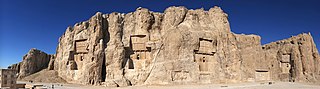
English: Panorama of Naqsh-e Rostam, Shiraz, Iran.
Ελληνικά: Πανοραμική εικόνα του αρχαιολογικού χώρου Νάκσχ ε Ροστάμ, Σιράζ, Ιράν.
فارسی: سراسرنمای نقش رستم، شیراز، ایران.
Тоҷикӣ: Саросарнамои Нақши Рустам, Шероз, Эрон. |
| Date | |
| Source | Own work |
| Author | User:Ggia |
| Permission (Reusing this file) |
Creative Commons License 3.0 Share-Alike |
| Other versions |
|

|
| Camera location | | View this and other nearby images on: OpenStreetMap |
|---|
Licensing
This file is licensed under the Creative Commons Attribution-Share Alike 3.0 Unported license.
- You are free:
- to share – to copy, distribute and transmit the work
- to remix – to adapt the work
- Under the following conditions:
- attribution – You must give appropriate credit, provide a link to the license, and indicate if changes were made. You may do so in any reasonable manner, but not in any way that suggests the licensor endorses you or your use.
- share alike – If you remix, transform, or build upon the material, you must distribute your contributions under the same or compatible license as the original.
File history
Click on a date/time to view the file as it appeared at that time.
| Date/Time | Thumbnail | Dimensions | User | Comment | |
|---|---|---|---|---|---|
| current | 09:04, 21 January 2013 | 9,500 × 2,641 (18.18 MB) | Slick-o-bot | Bot: convert to a non-interlaced jpeg image (see bugzilla:17645) | |
| 19:34, 20 November 2011 | 9,500 × 2,641 (16.51 MB) | Ggia |
File usage
The following 5 pages use this file:
Global file usage
The following other wikis use this file:
- Usage on ca.wikipedia.org
- Usage on cs.wikipedia.org
- Usage on de.wikipedia.org
- Usage on de.wikivoyage.org
- Usage on el.wikipedia.org
- Usage on en.wikipedia.org
- Talk:Naqsh-e Rostam
- User talk:Ggia
- Wikipedia:Featured picture candidates/November-2012
- Wikipedia:Featured picture candidates/20101229 Naqsh e Rostam Shiraz Iran more Panoramic.jpg
- Wikipedia:Wikipedia Signpost/2012-11-26/Featured content
- Wikipedia:Wikipedia Signpost/Single/2012-11-26
- Wikipedia:Picture of the day/April 2014
- Template:POTD/2014-04-06
- Wikipedia:Main Page history/2014 April 6
- User talk:Alborzagros/Archive 3
- Wikipedia:Featured picture candidates/delist/2019
- Wikipedia:Featured picture candidates/delist/Naqsh-e Rustam
- Usage on en.wikiquote.org
- Usage on en.wikivoyage.org
- Usage on es.wikipedia.org
- Wikipedia:Imágenes destacadas/Lugares/Asia
- Wikipedia:Recurso del día/601 - 700
- Arquitectura de Irán
- Wikipedia:Candidatos a recursos destacados/20101229 Naqsh e Rostam Shiraz Iran more Panoramic.jpg
- Wikipedia:Candidatos a recursos destacados/Mayo-2014
- Wikipedia:Recurso del día/junio de 2014
- Plantilla:RDD/691
- Wikipedia:Recurso del día/septiembre de 2015
- Usuario discusión:Broyito
- Usuario discusión:Fergthh
- Arte sasánida
- Wikipedia:Recurso del día/noviembre de 2017
- Usuario discusión:Eiriarte
- Wikipedia:Recurso del día/febrero de 2020
- Wikipedia:Recurso del día/septiembre de 2022
- Usage on fa.wikipedia.org
- شهرستان مرودشت
- درگاه:ایران
- ویکیپدیا:گزیدن نگاره برگزیده/دسامبر-۲۰۱۱
- ویکیپدیا:نگارههای برگزیده/جاها/سراسرنما
- درگاه:ایران/سراسرنمای برگزیده
- درگاه:ایران/سراسرنمای برگزیده/۵
- ویکیپدیا:نگاره روز/اوت ۲۰۱۲
- درگاه:جغرافیا/سراسرنمای برگزیده
- درگاه:جغرافیا/سراسرنمای برگزیده/۳
- ویکیپدیا:گزیدن نگاره برگزیده/20101229 Naqsh e Rostam Shiraz Iran more Panoramic.jpg
- الگو:نر/2012-08-31
- الگو:نر محافظت شده/2012-08-31
- درگاه:هخامنشیان/سراسرنمای برگزیده
View more global usage of this file.