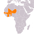
File:Africa-countries-UEMOA.png
Africa-countries-UEMOA.png (360 × 392 pixels, file size: 12 KB, MIME type: image/png)
File history
Click on a date/time to view the file as it appeared at that time.
| Date/Time | Thumbnail | Dimensions | User | Comment | |
|---|---|---|---|---|---|
| current | 15:50, 9 July 2011 |  | 360 × 392 (12 KB) | Maphobbyist | South Sudan has become independent on July 9, 2011. Sudan and South Sudan are shown with the new international border between them. |
| 11:25, 16 August 2009 |  | 360 × 392 (12 KB) | IJA | Gaza, Montenegro, Kosovo, Croatia, Bosnia-Herzegovina updated. Also made orange to stand out more. | |
| 19:26, 6 August 2005 |  | 360 × 392 (8 KB) | Sven-steffen arndt | :'''Description''': Map of African Countries of UEMOA :'''Beschreibung''': Karte von afrikanischen Ländern der UEMOA :old image originally from Wikimedia Commons Image:BlankMap-Africa.png :new image is self-created :'''created by''' [[:de:Benutzer:S |
File usage
There are no pages that use this file.
Global file usage
The following other wikis use this file:
- Usage on de.wikipedia.org
- Usage on frr.wikipedia.org
- Usage on ko.wikipedia.org


