
File:Back-scattering crepuscular rays panorama 1.jpg

Size of this preview: 800 × 296 pixels. Other resolutions: 320 × 118 pixels | 640 × 237 pixels | 1,024 × 379 pixels | 1,280 × 474 pixels | 3,400 × 1,259 pixels.
Original file (3,400 × 1,259 pixels, file size: 2.22 MB, MIME type: image/jpeg)
Summary
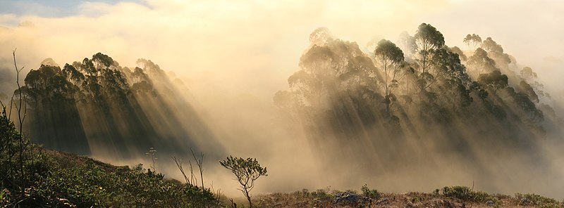
This image was selected as picture of the day on Wikimedia Commons for 26 September 2010. It was captioned as follows: English: Back-scattering Crepuscular rays. Other languages:
Čeština: Rozptyl krepuskulárních paprsků Dansk: Tusmørkestråler. Deutsch: Rückwärts gestreute Dämmerungsstrahlen English: Back-scattering Crepuscular rays. Español: Panorámica de la Golden Gate National Recreation Area localizada en San Francisco, California. Nederlands: Panorama over het Golden Gate National Recreation Area (rondom de Baai van San Francisco) met terugstralende wolkenstralen. Português: Panorama do Golden Gate National Recreation Area localizado em São Francisco, Califórnia. Македонски: Назадно-распрснати самрачни зраци. മലയാളം : ക്രെപ്പുസ്കുലാർ കിരണങ്ങളുടെ വിസരണം. 日本語: 薄明光線が降りそそぐ。 中文: 云隙光 |
|

| This is a retouched picture, which means that it has been digitally altered from its original version. Modifications: Stitching and some cloning were done manually.
|
| Description |
English: Back-scattering crepuscular rays. The image was sent to Dr. Andrew T. Young. Here's his description:
"... it's unusual to see these shadows so clearly at such an oblique geometry: usually, the crepuscular rays are best seen in forward scattering, and much less well in back-scattering. But here, you're looking almost at right angles to the illuminating rays". Deutsch: Rückwärts gestreute Dämmerungsstrahlen. Das Bild ist zu Dr. Andrew T. Young gesandt worden, der es wie folgt kommentierte:
„... es ist ungewöhnlich, diese Schatten so klar bei einem so schiefen Winkel zu sehen: Üblicherweise sind Dämmerungsstrahlen am besten vorwärts gestreut zu beobachten und deutlich schlechter rückwärts gestreut. Aber hier blickst Du fast rechtwinklig auf die Strahlenbüschel.“ (Aus dem Englischen übersetzt.) Suomi: Taaksepäin siroavia hämäränsäteitä.
Français : Rétrodiffusion des rayons crépusculaires par les arbres du Golden Gate National Recreation Area en Californie, aux États-Unis. |
| Date | |
| Source | Own work |
| Author | Brocken Inaglory |
| Other versions |
|


| Camera location | | View this and other nearby images on: OpenStreetMap |
|---|
Licensing
I, the copyright holder of this work, hereby publish it under the following licenses:
This file is licensed under the Creative Commons Attribution-Share Alike 3.0 Unported license.
- You are free:
- to share – to copy, distribute and transmit the work
- to remix – to adapt the work
- Under the following conditions:
- attribution – You must give appropriate credit, provide a link to the license, and indicate if changes were made. You may do so in any reasonable manner, but not in any way that suggests the licensor endorses you or your use.
- share alike – If you remix, transform, or build upon the material, you must distribute your contributions under the same or compatible license as the original.

|
Permission is granted to copy, distribute and/or modify this document under the terms of the GNU Free Documentation License, Version 1.2 or any later version published by the Free Software Foundation; with no Invariant Sections, no Front-Cover Texts, and no Back-Cover Texts. A copy of the license is included in the section entitled GNU Free Documentation License. |
You may select the license of your choice.
File history
Click on a date/time to view the file as it appeared at that time.
| Date/Time | Thumbnail | Dimensions | User | Comment | |
|---|---|---|---|---|---|
| current | 00:00, 3 October 2009 | 3,400 × 1,259 (2.22 MB) | Mbz1 | {{Information |Description={{en|1=rays}} |Source={{own}} |Author=Mbz1 |Date= |Permission= |other_versions= }} |
File usage
The following page uses this file:
Global file usage
The following other wikis use this file:
- Usage on be-tarask.wikipedia.org
- Usage on be.wikipedia.org
- Usage on bn.wikipedia.org
- Usage on crh.wikipedia.org
- Usage on cv.wikipedia.org
- Usage on da.wikipedia.org
- Usage on de.wikipedia.org
- Usage on eo.wikipedia.org
- Usage on es.wikipedia.org
- Usage on fa.wikipedia.org
- Usage on fr.wikipedia.org
- Usage on hu.wikipedia.org
- Usage on hy.wikipedia.org
- Usage on id.wikipedia.org
- Usage on ko.wikipedia.org
- Usage on lbe.wikipedia.org
- Usage on mk.wikipedia.org
- Usage on mn.wikipedia.org
- Usage on os.wikipedia.org
- Usage on ps.wikipedia.org
- Usage on ru.wikipedia.org
- Usage on ru.wikinews.org
- Usage on sah.wikipedia.org
- Usage on uk.wikipedia.org
- Usage on vi.wikipedia.org
- Usage on xal.wikipedia.org
- Usage on zh.wikipedia.org