
File:Cevennes Florac Mimente depuis Causse Mejean.jpg

Size of this preview: 800 × 480 pixels. Other resolutions: 320 × 192 pixels | 1,024 × 614 pixels | 1,280 × 768 pixels | 2,560 × 1,535 pixels | 4,028 × 2,416 pixels.
Original file (4,028 × 2,416 pixels, file size: 7.02 MB, MIME type: image/jpeg)
Summary
| Description |
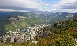
Français : Vue depuis le bord du causse Méjean : Florac, le Bougès, la vallée de la Mimente dans le parc national des Cévennes (Lozère, France)
English: View from the edge of Causse Méjean: Florac, Bougès Mountain and the valley of the Mimente river in the Cévennes National Park, Lozère, France. |
| Date | |
| Source | Own work |
| Author | Myrabella |
| Attribution (required by the license) | Photo: Myrabella / Wikimedia Commons / |
| Camera location | | View this and other nearby images on: OpenStreetMap |
|---|
This image has been assessed using the Quality image guidelines and is considered a Quality image.
|
Licensing
I, the copyright holder of this work, hereby publish it under the following license:
This file is licensed under the Creative Commons Attribution-Share Alike 3.0 Unported license.
- You are free:
- to share – to copy, distribute and transmit the work
- to remix – to adapt the work
- Under the following conditions:
- attribution – You must give appropriate credit, provide a link to the license, and indicate if changes were made. You may do so in any reasonable manner, but not in any way that suggests the licensor endorses you or your use.
- share alike – If you remix, transform, or build upon the material, you must distribute your contributions under the same or compatible license as the original.
File history
Click on a date/time to view the file as it appeared at that time.
| Date/Time | Thumbnail | Dimensions | User | Comment | |
|---|---|---|---|---|---|
| current | 23:13, 18 November 2012 | | 4,028 × 2,416 (7.02 MB) | Myrabella | == {{int:filedesc}} == {{Information |Description= {{fr|1=Vue depuis le bord du causse Méjean : Florac, le Bougès, la vallée de la Mimente dans le [[:fr:parc national des Cévenne... |
File usage
The following page uses this file:
Global file usage
The following other wikis use this file:
- Usage on af.wikipedia.org
- Usage on ar.wikipedia.org
- Usage on arz.wikipedia.org
- Usage on ast.wikipedia.org
- Usage on ca.wikipedia.org
- Usage on cs.wikipedia.org
- Usage on da.wikipedia.org
- Usage on de.wikipedia.org
- Usage on en.wikipedia.org
- Usage on en.wikivoyage.org
- Usage on eo.wikipedia.org
- Usage on es.wikipedia.org
- Usage on et.wikipedia.org
- Usage on eu.wikipedia.org
- Usage on fr.wikipedia.org
- Usage on fr.wikibooks.org
- Usage on fr.wikivoyage.org
- Usage on gl.wikipedia.org
- Usage on he.wikipedia.org
- Usage on he.wikivoyage.org
- Usage on hsb.wikipedia.org
- Usage on hy.wikipedia.org
- Usage on ia.wikipedia.org
- Usage on is.wikipedia.org
- Usage on it.wikipedia.org
View more global usage of this file.