
File:Ice planet and antarctic jellyfish.jpg

Original file (4,256 × 2,832 pixels, file size: 7.21 MB, MIME type: image/jpeg)
Summary
| Description |
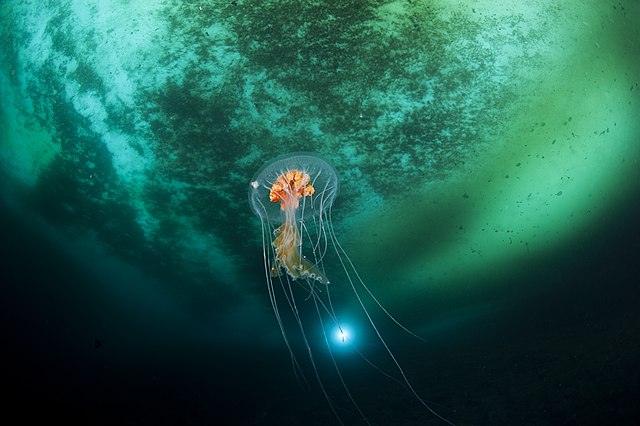
English: Underwater Antarctic biodiversity (French scientific base in Antarctica). Identified as Diplulmaris antarctica by Prof. Andre C. Morandini:
Français : méduse dans son environnement, ici élément de la biodiversité antarctique ; base scientifique antarctique
Deutsch: Biodiversität unter Wasser in der Antarktis (französische Wissenschaftsstation in der Antarktis). Von Prof. André C. Morandini als Diplulmaris antarctica identifiziert. Gehört zu den Schirmquallen. |
|||
| Date | ||||
| Source | Own work | |||
| Author | Erwan AMICE | |||
| Other versions |
.jpg)
.jpg)
| Camera location | | View this and other nearby images on: OpenStreetMap |
|---|
| This image was uploaded as part of Wiki Science Competition 2017. |
Assessment
|

Licensing
- You are free:
- to share – to copy, distribute and transmit the work
- to remix – to adapt the work
- Under the following conditions:
- attribution – You must give appropriate credit, provide a link to the license, and indicate if changes were made. You may do so in any reasonable manner, but not in any way that suggests the licensor endorses you or your use.
File history
Click on a date/time to view the file as it appeared at that time.
| Date/Time | Thumbnail | Dimensions | User | Comment | |
|---|---|---|---|---|---|
| current | 14:00, 8 February 2019 | | 4,256 × 2,832 (7.21 MB) | SteinsplitterBot | Bot: Image rotated by 180° |
| 10:37, 10 November 2017 |  | 4,256 × 2,832 (7.06 MB) | AMICE | User created page with UploadWizard |
File usage
The following page uses this file:
Global file usage
The following other wikis use this file:
- Usage on da.wikipedia.org
- Usage on fr.wikipedia.org
- Usage on he.wikipedia.org
- Usage on ru.wikimedia.org
- Конкурсы/Конкурс научных фотографий 2018/en
- Конкурсы/Конкурс научных фотографий 2018/tt
- Конкурсы/Конкурс научных фотографий 2019/tt
- Конкурсы/Конкурс научных фотографий 2019/en
- Конкурсы/Конкурс научных фотографий 2020/tt
- Конкурсы/Конкурс научных фотографий 2020/en
- Конкурсы/Конкурс научных фотографий 2021/en
- Конкурсы/Конкурс научных фотографий 2021/tt
- Usage on su.wikipedia.org
- Usage on sv.wikipedia.org
- Usage on vi.wikipedia.org