
File:Kaubalaeva "E. Russ" vrakk.jpg

Size of this preview: 800 × 450 pixels. Other resolutions: 320 × 180 pixels | 640 × 360 pixels | 1,024 × 576 pixels | 1,280 × 720 pixels | 1,920 × 1,080 pixels.
Original file (1,920 × 1,080 pixels, file size: 1.51 MB, MIME type: image/jpeg)
Summary
| Description |
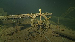
Eesti: Kaubalaeva "E. Russ" vrakk. Vaade roolirattale. Hiiumaa saarest põhjas.
English: Wreck of cargo ship "E. Russ". Steering wheel. Located north from island Hiiumaa in Estonia.
Polski: Koło sterowe wraku statku towarowego „E. Russ”. Wrak znajduje się na północ od estońskiej wyspy Hiuma.
Português: Restos do naufrágio do navio cargueiro "E. Russ", perto da ilha estoniana de Hiiumaa, no mar Báltico.
Українська: Штурвал і залишки британського вантажного пароплава «Е. Русс», що підірвався на морській міні і затонув 15 вересня 1919. Балтійське море на північ від півострова Тахкуна острова Гіюмаа.
|
||
| Date | |||
| Source | Muinsuskaitseamet | ||
| Author | Juha Flinkman, SubZone OY | ||
| Permission (Reusing this file) |
| Camera location | | View this and other nearby images on: OpenStreetMap |
|---|
Assessment
|

This image was selected as picture of the day on Wikimedia Commons for 28 September 2015. It was captioned as follows: Other languages:
Português: Restos do naufrágio do navio cargueiro "E. Russ", perto da ilha estoniana de Hiiumaa, no mar Báltico. |
Licensing
This file is licensed under the Creative Commons Attribution-Share Alike 4.0 International license.
- You are free:
- to share – to copy, distribute and transmit the work
- to remix – to adapt the work
- Under the following conditions:
- attribution – You must give appropriate credit, provide a link to the license, and indicate if changes were made. You may do so in any reasonable manner, but not in any way that suggests the licensor endorses you or your use.
- share alike – If you remix, transform, or build upon the material, you must distribute your contributions under the same or compatible license as the original.
File history
Click on a date/time to view the file as it appeared at that time.
| Date/Time | Thumbnail | Dimensions | User | Comment | |
|---|---|---|---|---|---|
| current | 17:16, 3 March 2015 | | 1,920 × 1,080 (1.51 MB) | Kruusamägi | User created page with UploadWizard |
File usage
The following page uses this file:
Global file usage
The following other wikis use this file:
- Usage on ar.wikipedia.org
- Usage on be-tarask.wikipedia.org
- Usage on bn.wikipedia.org
- Usage on ca.wikipedia.org
- Usage on crh.wikipedia.org
- Usage on cv.wikipedia.org
- Usage on de.wikipedia.org
- Usage on de.wiktionary.org
- Usage on dsb.wikipedia.org
- Usage on en.wikipedia.org
- Usage on es.wikipedia.org
- Usage on et.wikipedia.org
- Usage on et.wikiquote.org
- Usage on fr.wikiversity.org
- Usage on he.wikipedia.org
- Usage on hu.wikipedia.org
- Usage on it.wikipedia.org
- Usage on ka.wikipedia.org
- Usage on ko.wikipedia.org
- Usage on krc.wikipedia.org
- Usage on lbe.wikipedia.org
- Usage on li.wiktionary.org
- Usage on mg.wikipedia.org
- Usage on ms.wikipedia.org
- Usage on nl.wikipedia.org
- Usage on os.wikipedia.org
- Usage on pt.wikipedia.org
- Usage on ru.wikipedia.org
- Usage on ru.wikinews.org
- Usage on sah.wikipedia.org
- Usage on tt.wikipedia.org
- Usage on uk.wikipedia.org
- Usage on zh.wikipedia.org