
File:Stylodipus telum falzfeini habitat.tif

Size of this PNG preview of this TIF file: 800 × 513 pixels. Other resolutions: 320 × 205 pixels | 640 × 410 pixels | 1,024 × 657 pixels | 1,280 × 821 pixels | 2,560 × 1,642 pixels | 3,387 × 2,172 pixels.
Original file (3,387 × 2,172 pixels, file size: 2.08 MB, MIME type: image/tiff)
Summary
| Description |
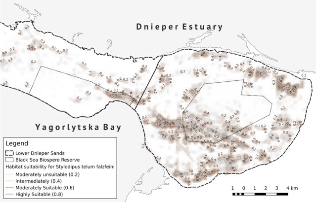
Українська: Кандибка пустельний Фальц-Фейна (Stylodipus telum falzfeini Brauner, 1913) — ендемічний підвид з дуже малим ареалом, який обмежений лише територією Олешських (або Нижньодніпровських) пісків. Господарське освоєння регіону, особливо створення лісових насаджень, зумовили істотну фрагментацію і скорочення площі оселищ кандибки протягом останнього століття. Шляхом аналізу екологічної ніші цього виду із застосуванням геоінформаційних технологій та методів багатовимірної статистики, на основі вегетаційних індексів (обчислених за даними дистанційного зондування Landsat 8) вдалося змоделювати мапу придатності оселищ для кандибки. На рисунку представлений фрагмент мапи для регіону аренних ділянок Чорноморського біосферного заповідника (Іванівська піщана арена та коренева частина Кінбурнського півострова). Моделювання просторового поширення кандибки дасть можливість встановити яку частку території Олешських пісків наразі займає популяція цього виду, провести ретроспективний аналіз змін поширення та оцінити ризик вимирання його популяції в регіоні дослідження, планувати подальший моніторинг динаміки популяції та розробляти заходи з охорони. English: The thick-tailed three-toed jerboa Falz-Feini (Stylodipus telum falzfeini Brauner, 1913) is an endemic subspecies with a very small range, which is limited only to the territory of Oleshski sands (or Lower Dnieper Sands). The economic development of the region, especially the creation of forest plantations, has resulted in significant fragmentation and reduction of the jerboa habitats during the last century. The jerboa habitat suitability map was modeled by analyzing the ecological niche on the basis of vegetation indices (computed from Landsat 8 remote sensing data) using geoinformation technologies and multidimensional statistics. The part of the habitat suitability map for jerboa for the region of the Black Sea Biosphere Reserve (Ivanivska Sand Aren and the root part of the Kinburn Peninsula) is shown on the picture. The spatial distribution modeling of the jerboa is very useful for some reasons. It allows to determine which part of the Oleshski Sands is occupied by the jerboa, to analyze the retrospective spatial distributional changes and to assess the risk of the jerboa population extinction, to plan further monitoring of the jerboa population dynamics and to development of the protection measures. |
| Date | |
| Source | Own work |
| Author | Yu Moskalenko |
Licensing
I, the copyright holder of this work, hereby publish it under the following license:
This file is licensed under the Creative Commons Attribution-Share Alike 4.0 International license.
- You are free:
- to share – to copy, distribute and transmit the work
- to remix – to adapt the work
- Under the following conditions:
- attribution – You must give appropriate credit, provide a link to the license, and indicate if changes were made. You may do so in any reasonable manner, but not in any way that suggests the licensor endorses you or your use.
- share alike – If you remix, transform, or build upon the material, you must distribute your contributions under the same or compatible license as the original.
| This image was uploaded as part of Wiki Science Competition 2017. |
File history
Click on a date/time to view the file as it appeared at that time.
| Date/Time | Thumbnail | Dimensions | User | Comment | |
|---|---|---|---|---|---|
| current | 08:27, 28 November 2017 |  | 3,387 × 2,172 (2.08 MB) | Yu Moskalenko | User created page with UploadWizard |
File usage
The following page uses this file:
Global file usage
The following other wikis use this file:
- Usage on uk.wikipedia.org