
Brahmapur railway station
Brahmapur | |||||||||||
|---|---|---|---|---|---|---|---|---|---|---|---|
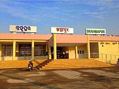
 Brahmapur station main entrance | |||||||||||
| General information | |||||||||||
| Location | Brahmapur, Odisha, PIN-760001 India | ||||||||||
| Coordinates | 19°17′48″N 84°47′48″E / 19.2966°N 84.7968°E | ||||||||||
| Elevation | 43 m (141 ft) | ||||||||||
| Owned by | Indian Railways | ||||||||||
| Operated by | Indian Railways | ||||||||||
| Line(s) | Howrah-Chennai main line, Khurda Road–Visakhapatnam section | ||||||||||
| Platforms | 4 | ||||||||||
| Tracks | 5 | ||||||||||
| Connections | Taxi stand, Auto stand, Bus stand, Availability of wheel chair system& High-speed Rail wire WiFi system provided by RailTel (Govt.of India) | ||||||||||
| Construction | |||||||||||
| Structure type | Standard (on-ground station) | ||||||||||
| Parking | Available | ||||||||||
| Accessible | |||||||||||
| Other information | |||||||||||
| Status | Functioning | ||||||||||
| Station code | BAM | ||||||||||
| Zone(s) | East Coast Railway zone | ||||||||||
| Division(s) | Khurda Road | ||||||||||
| Classification | Non-Suburban Grade-3 (NSG-3) | ||||||||||
| History | |||||||||||
| Opened | 1896 | ||||||||||
| Electrified | Yes | ||||||||||
| Previous names | East Coast State Railway, Bengal Nagpur Railway | ||||||||||
| Passengers | |||||||||||
| 11958+ | |||||||||||
| Services | |||||||||||
| |||||||||||
| Location | |||||||||||
 Brahmapur Location in Odisha  Brahmapur Location in India | |||||||||||
Brahmapur is a major and one of the oldest railway stations in the Indian state of Odisha. Brahmapur well known as “The Silk City", is a city on the eastern coastline of the state of Odisha. Brahmapur Railway Station is one of the oldest Railway Station and it is administered under Khurda Road railway division of East Coast Railway zone. This station is classified as Non-Suburban Grade-3 (NSG-3) Category Station earlier categorized as ‘A’ category station. An average foot fall of 12,000 nos. are dealt here on daily basis. It is one of the major hub for Education & Business (food and garment) and railway provide hassle-free connectivity to this place. Brahmapur is famous for its tourist attraction. Tara Tarini an ancient Shakti peetha, Breast shrine of Adi Shakti and one amongst the 4 major Shakti Peeethas in India is 25 km from the city. In addition, the world famous Gopalpur-on-Sea sea beach, Bhairabi & MahuriKalia temples, and Tampara lake are around 10km from the city. The famous Chilika Lake at Rambha and Taptapani Hot Springs are around 45 km from from the city. It is silk city so silk products are cheap and readily available. This place is also famous for a variety of pickles, mixtures and papad.
History[edit]
During the period of 1893 to 1896, (1,287 km (800 mi) of East Coast State Railway) this historic Brahmapur station was built and opened to traffic in 1896. Bengal Nagpur Railway's line to Brahmapur (Berhampur) was opened on 1 January 1899.[1]
The 514 km (319 mi) long northern section of the South Eastern Railway was merged with BNR in 1902.[2]
Railway reorganization[edit]
The Bengal Nagpur Railway was nationalized in 1944.[3]Eastern Railway was formed on 14 April 1952 with the portion of East Indian Railway Company east of Mughalsarai and the Bengal Nagpur Railway.[4] In 1955, South Eastern Railway was carved out of Eastern Railway. It comprised lines mostly operated by BNR earlier.[4][5] Amongst the new zones started in April 2003 were East Coast Railway and South East Central Railway. Both these railways were carved out of South Eastern Railway.[4]
Accessibility[edit]
- Distance from City Bus Stand 3 kilometres (1.9 mi)
- Distance from New Bus Stand(Haldiapadar) 5 kilometres (3.1 mi)
- Distance from MKCG Hospital 3 kilometres (1.9 mi)
- Distance from Berhampur University 11 kilometres (6.8 mi)
- Distance from Army AD College 14 kilometres (8.7 mi)
- Distance from Gopalpur Sea Beach 16 kilometres (9.9 mi)
- Distance from Sonapur Sea Beach 31 kilometres (19 mi)
- Distance from Khallikote University1.5 kilometres (0.93 mi)
- Distance from Tampara Lake 25 kilometres (16 mi)
The nearest international airport is Biju Patnaik International Airport (172 km)
Gallery[edit]
-
 Newly inaugurated entrance and booking office
 -
 Early morning at Brahmapur railway station
 -
 Brahmapur railway station on a rainy day
 -
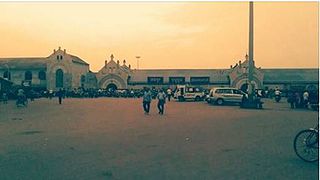
 Railway station at dusk
 -
 View from foot overbridge on a rainy day


References[edit]
- ^ "Major Events in the Formation of S.E. Railway". South Eastern Railway. Archived from the original on 1 April 2013. Retrieved 2013-01-02.
- ^ "History". East Coast Railway. Archived from the original on 31 January 2011. Retrieved 2 January 2013.
- ^ "IR History: Part - III (1900–1947)". IRFCA. Retrieved 21 November 2012.
- ^ a b c "Geography – Railway Zones". IRFCA. Retrieved 21 November 2012.
- ^ "IR History: Part - IV (1947–1970)". IRFCA. Retrieved 21 November 2012.
External links[edit]
- Trains at Brahmapur
 Brahmapur travel guide from Wikivoyage
- Gopalpur-on-sea travel guide from Wikivoyage