
Taunggyi
This article needs additional citations for verification. (March 2022) |
Taunggyi
| |
|---|---|
City | |
 A view of Taunggyi | |
 Taunggyi Location of Taunggyi, Myanmar | |
| Coordinates: 20°47′N 97°02′E / 20.783°N 97.033°E | |
| Country | |
| State | |
| District | Taunggyi District |
| Township | Taunggyi Township |
| Founded | 1894 |
| Elevation | 4,590 ft (1,400 m) |
| Population | |
| • City | 381,639 |
| • Urban | 264,804 |
| • Rural | 116,835 |
| • Ethnicities | Pa-O Tai Burmese Chinese Shan Burmese Indians Gurkha |
| • Religions | Buddhism Christianity Islam |
| Demonym | Taunggese |
| Time zone | UTC+6.30 (MST) |
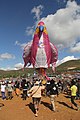
Taunggyi (Burmese: တောင်ကြီးမြို့; MLCTS: taung kri: mrui. [tàʊɰ̃dʑí mjo̰]; Shan: ဝဵင်းတူၼ်ႈတီး Shan pronunciation: [weŋ˥ ton˧˧˨ ti˥]) is the capital and largest city of Shan State, Myanmar (Burma) and lies on the Thazi-Kyaingtong road at an elevation of 4,712 feet (1,436 m), just north of Shwenyaung and Inle Lake within the Myelat region.[2] Taunggyi is the fifth largest city of Myanmar,[3] and has an estimated population of 380,665 as of 2014.[4] The city is famous for its hot air balloon festival held annually on the full moon day of Tazaungmon.[5]
Etymology[edit]
The name Taunggyi means "huge mountain" in the Burmese language, and is named after the ridge on the east of the city, part of the Shan Hills system, whose prominent high point is called Taung-chun or "The Spur." Locally this spur is popularly known as Phaya Taung. The ridge has a more prominent and more popular feature known as Chauk Talone, meaning the Craigs.
History[edit]
Prior to British colonisation, Taunggyi was a small Pa'O village of a few huts and the majority of Shan ethnic. The area lay on a wide shoulder of the Sittaung Hills of the Shan Hills and was populated by those ethnicities at the time. The signs of the original village of Taunggyi are long gone, but nearby villages can still be discerned quite easily.
During British occupation, the town became the chief city and capital of the Southern Shan States. Taunggyi's modern development began in 1894, when the British moved their administrative offices from Maing Thauk (Fort Stedman) on the eastern shores of Inle Lake to the higher elevation of Taunggyi, for health and geographical reasons. Although geographically within the state of Yawnghwe, the town was denoted as a "notified area" by the British, exempt from the Sawbwa's administration. By 1906, there existed a thousand houses. Because of civil unrest throughout the Shan States during the early 1900s, Taunggyi served as the chief garrison for military police. Taunggyi also served as a supply centre for the Shan States, and catered to persons of many nationalities.[6]
Geography[edit]
.jpg)
Taunggyi is at an elevation of 4,712 feet (1,436 m) above sea level. It sits on a high intermontaine basin (erroneously called a plateau) that rapidly descends to the western lowland river valleys that make up central Myanmar, but is otherwise surrounded by mountain range. The city is 635 kilometres (395 mi) from Yangon (Rangoun) by road.
Climate[edit]
Taunggyi has a humid subtropical climate (Köppen climate classification Cwa), closely bordering a subtropical highland climate (Cwb). There is a winter dry season (December–March) and a summer wet-season (April–November). Temperatures are very warm throughout the year; the winter months (December–February) are milder but the nights can be quite cool.
| Climate data for Taunggyi (1991–2020) | |||||||||||||
|---|---|---|---|---|---|---|---|---|---|---|---|---|---|
| Month | Jan | Feb | Mar | Apr | May | Jun | Jul | Aug | Sep | Oct | Nov | Dec | Year |
| Record high °C (°F) | 28.4 (83.1) |
33.0 (91.4) |
33.0 (91.4) |
34.3 (93.7) |
34.6 (94.3) |
34.0 (93.2) |
31.0 (87.8) |
30.2 (86.4) |
28.7 (83.7) |
30.2 (86.4) |
30.0 (86.0) |
29.7 (85.5) |
34.6 (94.3) |
| Mean daily maximum °C (°F) | 23.6 (74.5) |
25.7 (78.3) |
28.4 (83.1) |
29.5 (85.1) |
27.2 (81.0) |
25.3 (77.5) |
24.3 (75.7) |
24.1 (75.4) |
24.9 (76.8) |
25.1 (77.2) |
24.5 (76.1) |
23.2 (73.8) |
25.5 (77.9) |
| Daily mean °C (°F) | 16.2 (61.2) |
17.9 (64.2) |
21.0 (69.8) |
23.0 (73.4) |
22.5 (72.5) |
21.7 (71.1) |
21.2 (70.2) |
21.1 (70.0) |
21.3 (70.3) |
20.7 (69.3) |
18.8 (65.8) |
16.5 (61.7) |
20.1 (68.2) |
| Mean daily minimum °C (°F) | 8.7 (47.7) |
10.2 (50.4) |
13.6 (56.5) |
16.5 (61.7) |
17.7 (63.9) |
18.2 (64.8) |
18.1 (64.6) |
18.0 (64.4) |
17.7 (63.9) |
16.3 (61.3) |
13.1 (55.6) |
9.9 (49.8) |
14.8 (58.6) |
| Record low °C (°F) | 3.9 (39.0) |
5.0 (41.0) |
8.5 (47.3) |
11.5 (52.7) |
12.7 (54.9) |
13.2 (55.8) |
16.4 (61.5) |
16.2 (61.2) |
15.0 (59.0) |
10.0 (50.0) |
6.0 (42.8) |
3.0 (37.4) |
3.0 (37.4) |
| Average precipitation mm (inches) | 11.5 (0.45) |
4.4 (0.17) |
9.3 (0.37) |
51.4 (2.02) |
172.2 (6.78) |
170.6 (6.72) |
217.4 (8.56) |
300.8 (11.84) |
258.0 (10.16) |
182.2 (7.17) |
54.2 (2.13) |
12.7 (0.50) |
1,444.8 (56.88) |
| Average precipitation days (≥ 1.0 mm) | 1.0 | 0.5 | 1.5 | 6.1 | 15.0 | 19.3 | 22.4 | 24.5 | 20.5 | 14.6 | 5.2 | 1.6 | 132.3 |
| Average relative humidity (%) | 57 | 47 | 43 | 49 | 72 | 81 | 83 | 85 | 84 | 81 | 71 | 64 | 68.0 |
| Source 1: World Meteorological Organization[7] | |||||||||||||
| Source 2: Norwegian Meteorological Institute (extremes),[8] Climate Data (humidity),[9] Ogimet.com | |||||||||||||
Transportation[edit]
The main access to Taunggyi is by the mountainous road. A railway line that passes through Taunggyi was recently built in 1995, but at the moment[when?] it offers no passenger service to Taunggyi. Regular railway passenger service to the rest of the country is through the town of Shwenyaung, 12 miles (19 km) to the west. The nearest airport is Heho Airport, 24 mi (39 km) about an hour driving distance, by road to the west of Taunggyi. Heho Airport has regular flights to Yangon, Mandalay and Bagan.
Culture[edit]


Taunggyi is the melting pot for the Myelat area of the Shan State. Like in most of Myanmar, influence of Buddhism is most evidenced by the monasteries scattered throughout the city. However, being a relatively new city, the monasteries are not of historical significance and architecturally not unique. There is also a significant Christian population, as the center of the Roman Catholic Archdiocese of Taunggyi the St. Joseph's Cathedral and its associated seminary are the main facilities, as well as a Baptist church. Both churches were established by early missionaries. There is also a smaller Anglican church, which originally served the British administrators, but recently it has fallen into a state of disrepair. Four mosques serve the Muslim communities of the city. Among four mosques, Panthay mosque serves the Chinese Panthay Muslims mainly. The other mosques are for large population of Burmese Muslims. There are also a few temples serving the Chinese Buddhist community. After 1990s, Chinese migrants are settling in Taunggyi and now they constitute the considerable proportion in communities.
The Taunggyi celebration of the Tazaungdaing Festival, a national holiday marking the end of the rainy season, has achieved international notoriety. "...balloons with large fireworks displays attached are sent airborne – but if they don't rise quickly enough, the pyrotechnics rocket back towards to crowds – sending people scattering. Videos of balloons engulfed in flames exploding amongst onlookers have become wildly popular on YouTube."[10] There were nine people injured in 2018,[11][12] two deaths and 12 injuries in 2017,[13][14] and four deaths in 2014.[15][16]
Being the capital of the Shan State, Taunggyi hosts many government offices. The city also hosts Eastern Command of the Tatmadaw (Myanmar military) and it occupies a significant portion of the north-east area of the city. Shan State Cultural Museum lies in Taunggyi. The museum displays the Shan culture, as well as items of historical interest, such as the belongings of Sawbwa.
Economy[edit]
Tourism[edit]
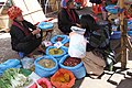
The Taunggyi area is a popular tourist destination. The city itself has an interesting five-day market, where farmers from around the area would come to the Taunggyi on market day and sell fresh produce in the open market, but with more development of the city, the significance of market day has been lessened. However, the market-day tradition continues strong in the outlying small towns. Nearby, Inle Lake is the home of the unique Intha culture. Inlay is famous for its traditional crafts industry and floating markets that are accessible via traditional longboats. The most unique thing is that Intha row the boat with their leg. On the way to the Pindaya Caves provides visitors with a good view of the Myelat countryside. Near Taunggyi, in Kekku, there are hundreds of stupas which dates back to 16th century.
Industry[edit]
There is no significant industry in Taunggyi. It used to be the trans-shipment point for many of the agricultural products of southern Shan State. However, due to recently imposed zoning regulations, most of these operations have been moved to the surrounding new town of Ayetharyar.
Agriculture[edit]
Another economy of Taunggyi is farming and gardening. Farmers around Taunggyi are mostly Shan and Pa-O ethnic origins. The main agricultural products of Taunggyi are potatoes, tea leaf, tomato, beans, damson and seasonal fruits.
Education[edit]
The city is home to:
- Taunggyi University
- University of Computer Studies, Taunggyi
- University of Medicine, Taunggyi
- Technological University, Taunggyi
- Taunggyi Education College
Sports[edit]
The 7,000-seat Taunggyi Stadium is a multi-use stadium in Taunggyi. The stadium is the home ground of Shan United FC, a Myanmar National League (MNL) football club.
Health care[edit]
Public Hospitals[edit]
- Sao San Tun General Hospital
- Taunggyi Women and Children Hospital
- Taunggyi University Hospital[17]
- Mettashin Charity Hospital-Eye Care Services
Gallery[edit]
-
 Taunggyi Sulamuni Pagoda
 -
 Technological University Taunggyi
 -
 Sulamani Pagoda at night
 -
 Hot air balloon Festival
 -
 Myoma Market
 -
 University of Medicine (Taunggyi)
 -
 A festival in Taunggyi


.jpg)


Notes[edit]
- ^ The 2014 Myanmar Population and Housing Census The Union Report Census Report Volume 2. Department of Population, Ministry of Immigration and Population. May 2015. p. 52. Archived from the original on 2016-03-06. Retrieved 2017-05-05.
- ^ "Taunggyi | Myanmar". Encyclopedia Britannica. Retrieved 2017-10-22.
- ^ "Biggest Cities In Myanmar (Burma)". WorldAtlas. Retrieved 2017-10-22.
- ^ "UNdata | record view | City population by sex, city and city type". data.un.org. Retrieved Apr 27, 2020.
- ^ "Taunggyi's fire balloon festival". The Myanmar Times. Archived from the original on 2017-10-22. Retrieved 2017-10-22.
- ^ Chisholm, Hugh, ed. (1911). . Encyclopædia Britannica. Vol. 26 (11th ed.). Cambridge University Press. pp. 452–453.
- ^ "World Meteorological Organization Climate Normals for 1991–2020". World Meteorological Organization. Retrieved 16 October 2023.
- ^ "Myanmar Climate Report" (PDF). Norwegian Meteorological Institute. pp. 23–36. Archived from the original (PDF) on 8 October 2018. Retrieved 28 October 2018.
- ^ "Climate and monthly weather forecast Taunggyi, Myanmar". Climate Data. Retrieved 18 April 2023.
- ^ "Taunggyi's fire balloon festival". The Myanmar Times.
- ^ "တောင်ကြီးတန်ဆောင်တိုင်ဖွင့်ပွဲမီးပုံးပျံ ပျက်ကျလို့ မီးလောင်ဒဏ်ရာရသူတွေရှိ". Nov 15, 2018. Retrieved Apr 27, 2020 – via www.bbc.com.
- ^ "Festival Revellers Run From Exploding Hot Air Balloon in Myanmar". uk.news.yahoo.com. Retrieved Apr 27, 2020.
- ^ "At Least 12 Injured at Taunggyi Balloon Festival". The Irrawaddy. Oct 31, 2017. Retrieved Apr 27, 2020.
- ^ "Myanmar's Deadly Hot Air Balloon Festival". thediplomat.com. Retrieved Apr 27, 2020.
- ^ Sandoval, Greg. "Exclusive Photos: Flaming hot air balloon explodes in crowd, killing 2 in Myanmar". Splinter. Retrieved Apr 27, 2020.
- ^ "Taunggyi Balloon Festival Deaths Rise to 4". The Irrawaddy. Nov 10, 2014. Retrieved Apr 27, 2020.
- ^ "ဦးကျော်ဝင်း ( ကန်ကြီးထောင့် မဲဆန္ဒနယ်)". www.pyithuhluttaw.gov.mm. Archived from the original on 2019-01-01. Retrieved 2019-01-01.
References[edit]


| 2,000,000 and more | |
|---|---|
| 1,000,000–1,999,999 | |
| 500,000–999,999 |
|
| 200,000–499,999 | |
| 100,000–199,999 | |
| International | |
|---|---|
| National | |