
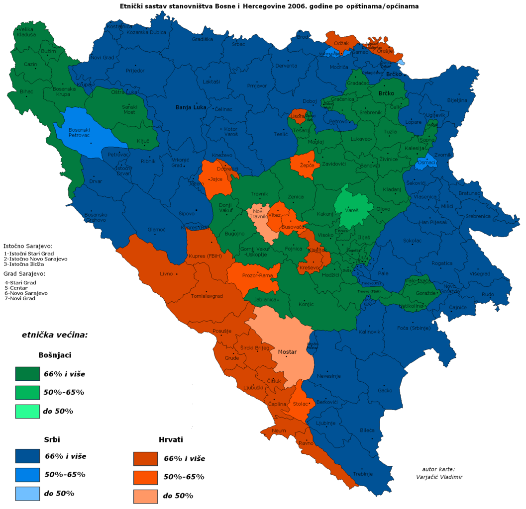
File:DemoBIH2006.PNG

Size of this preview: 619 × 599 pixels. Other resolutions: 248 × 240 pixels | 496 × 480 pixels | 793 × 768 pixels | 1,057 × 1,024 pixels | 1,809 × 1,752 pixels.
Original file (1,809 × 1,752 pixels, file size: 68 KB, MIME type: image/png)
| This is a file from the Wikimedia Commons. Information from its description page there is shown below. Commons is a freely licensed media file repository. You can help. |

Summary
| Description |
|
||
| Date | |||
| Source | http://commons.wikimedia.org/wiki/ | ||
| Author | Варја at Serbian Wikipedia (Vladimir Varjacic) | ||
| Other versions |
Derivative works of this file: DemoBIH2006a.png:  BiHDemo2006.png:  |

Licensing

|
Permission is granted to copy, distribute and/or modify this document under the terms of the GNU Free Documentation License, Version 1.2 or any later version published by the Free Software Foundation; with no Invariant Sections, no Front-Cover Texts, and no Back-Cover Texts. A copy of the license is included in the section entitled GNU Free Documentation License. |
| This file is licensed under the Creative Commons Attribution-Share Alike 3.0 Unported license. | ||
| Attribution: Vladimir Varjacic | ||
| ||
| This licensing tag was added to this file as part of the GFDL licensing update. |
File history
Click on a date/time to view the file as it appeared at that time.
| Date/Time | Thumbnail | Dimensions | User | Comment | |
|---|---|---|---|---|---|
| current | 14:57, 10 July 2015 | | 1,809 × 1,752 (68 KB) | Lilic | Reverted to version as of 08:40, 16 July 2007 |
| 08:40, 16 July 2007 |  | 1,809 × 1,752 (68 KB) | Nihad Hamzic | Greatly reduced image size by losslessly reducing color domain, and other optimisations. The image appearance is identical. | |
| 18:20, 17 February 2007 |  | 1,809 × 1,752 (212 KB) | Pokrajac | == Licensing == {{GFDL-no-disclaimers}} Category:Maps of the Federation of Bosnia and Herzegovina Category:Maps of Bosnia and Herzegovina | |
| 21:37, 29 December 2006 |  | 1,809 × 1,752 (211 KB) | Electionworld | {{ew|en|Estavisti}} == Summary == Taken from Serbian Wikipedia, the Republika Srpska article. It was created by a Serbian user based on various statistical data. There are some inaccuracies in the map (borders of Brčko district, etc.) == Licensing |
File usage
The following pages on the English Wikipedia use this file (pages on other projects are not listed):
Global file usage
The following other wikis use this file:
- Usage on es.wikipedia.org