
File:Flag of Norfolk Island.svg

Size of this PNG preview of this SVG file: 800 × 400 pixels. Other resolutions: 320 × 160 pixels | 640 × 320 pixels | 1,024 × 512 pixels | 1,280 × 640 pixels | 2,560 × 1,280 pixels | 920 × 460 pixels.
Original file (SVG file, nominally 920 × 460 pixels, file size: 23 KB)
Summary
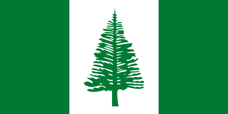
| Flag of Norfolk Island* | |
|---|---|
| used by | Norfolk Island |
| current since | 1980-01-17 |
| created by | |
| format | 1:2 |
| shape | rectangular |
| colours | green, white |
| other characteristics | flag has 3 vertical stripes flag includes depiction of the animal/plant Araucaria heterophylla |
English: Flag of Norfolk Island, Australia
Pih: Norfuk Ailen flag, Ostrielya
Cymraeg: Baner Ynys Norfolk, Awstralia
Deutsch: Flagge von Norfolk Island, Australien
Español: Bandera de la Isla Norfolk, Australia
Français : Drapeau de l'île Norfolk, Australie
Kernowek: Baner Ynys Norfolk, Ostrali
Plattdüütsch: Flagg vun dat Norfolk-Eiland, Australien
from the Open Clip Art website
Licensing
|
This file is from the Open Clip Art Library, which released it explicitly into the public domain (see here).
To the uploader: Please provide as parameter the link to the page where this image appears. |
| This file is made available under the Creative Commons CC0 1.0 Universal Public Domain Dedication. | |
| The person who associated a work with this deed has dedicated the work to the public domain by waiving all of their rights to the work worldwide under copyright law, including all related and neighboring rights, to the extent allowed by law. You can copy, modify, distribute and perform the work, even for commercial purposes, all without asking permission.
|

|
This image shows a flag, a coat of arms, a seal or some other official insignia. The use of such symbols is restricted in many countries. These restrictions are independent of the copyright status. |
File history
Click on a date/time to view the file as it appeared at that time.
| Date/Time | Thumbnail | Dimensions | User | Comment | |
|---|---|---|---|---|---|
| current | 12:05, 30 August 2023 | | 920 × 460 (23 KB) | 9BBWMJ | Reverted to version as of 23:42, 29 August 2023 (UTC) |
| 02:56, 30 August 2023 |  | 920 × 460 (20 KB) | Israelj123 | This is not an over-write, it is a colour correction per sources, which COM:OVERRIITE says is permitted. Going through all my past valid colour corrections which do NOT violate COM:OVERWRITE is stupid. | |
| 23:42, 29 August 2023 |  | 920 × 460 (23 KB) | NorthTension | Reverted to version as of 19:16, 10 May 2014 (UTC) not the flag | |
| 22:48, 29 August 2023 |  | 920 × 460 (20 KB) | Israelj123 | Made tree detailed. No other changes. | |
| 19:16, 10 May 2014 |  | 920 × 460 (23 KB) | SiBr4 | Code | |
| 22:46, 6 March 2011 |  | 920 × 460 (27 KB) | Zscout370 | Update according to NORFOLK ISLAND FLAG AND PUBLIC SEAL ACT 1979 | |
| 21:27, 9 May 2008 |  | 1,000 × 500 (39 KB) | Avala | green fix | |
| 02:44, 28 January 2006 |  | 1,000 × 500 (39 KB) | Denelson83 | Change tree outline to green colour | |
| 22:51, 24 November 2005 |  | 992 × 496 (21 KB) | Nightstallion | Flag of Norfolk Island from the [http://openclipart.org/ Open Clip Art] website. {{PD-OpenClipart}} Category:SVG flags |
File usage
The following page uses this file:
Global file usage
The following other wikis use this file:
- Usage on af.wikipedia.org
- Nieu-Seeland
- Lys van hoofstede
- Stille Oseaan
- Vlag van Australië
- Lys van lande
- Lys van lande volgens oppervlak
- Sjabloon:Landdata Norfolkeiland
- Oseanië
- Deelstate en gebiede van Australië
- Norfolkeiland
- Lys van lande volgens kuslynlengte
- Lys van afhanklike gebiede
- Vlag van Nigerië
- Kingston, Norfolk
- Kategorie:Norfolkeiland
- .nf
- Vlae van deelstate en gebiede van Australië
- Vlae van Oseanië
- Vlag van Norfolkeiland
- Vlag van Libanon
- Usage on als.wikipedia.org
- Usage on am.wikipedia.org
- Usage on an.wikipedia.org
- Usage on ar.wikipedia.org
View more global usage of this file.