
File:Latrans-Turkey location Istanbul.svg

Size of this PNG preview of this SVG file: 800 × 356 pixels. Other resolutions: 320 × 142 pixels | 640 × 285 pixels | 1,024 × 455 pixels | 1,280 × 569 pixels | 2,560 × 1,138 pixels | 1,473 × 655 pixels.
Original file (SVG file, nominally 1,473 × 655 pixels, file size: 10.88 MB)
Summary
| Description |
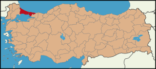
English: Location map for Istanbul.
Türkçe: İstanbul'un konumunu gösteren harita. |
| Date | |
| Source | Own work |
| Author |
|
Licensing
I, the copyright holder of this work, hereby publish it under the following license:
This file is licensed under the Creative Commons Attribution 3.0 Unported license.
- You are free:
- to share – to copy, distribute and transmit the work
- to remix – to adapt the work
- Under the following conditions:
- attribution – You must give appropriate credit, provide a link to the license, and indicate if changes were made. You may do so in any reasonable manner, but not in any way that suggests the licensor endorses you or your use.
File history
Click on a date/time to view the file as it appeared at that time.
| Date/Time | Thumbnail | Dimensions | User | Comment | |
|---|---|---|---|---|---|
| current | 08:30, 25 June 2009 | | 1,473 × 655 (10.88 MB) | The Emirr | {{Information |Description={{en|1=Location map for Istanbul.}} |Source=Own work by uploader |Author=The Emirr |Date=25.06.2009 |Permission={{The Emirr}} |other_versions=There is not another version. }} Location map for Istanbul. <!--{{I |
File usage
The following page uses this file:
Global file usage
The following other wikis use this file:
- Usage on af.wikipedia.org
- Usage on arc.wikipedia.org
- Usage on ar.wikipedia.org
- Usage on arz.wikipedia.org
- Usage on ast.wikipedia.org
- Usage on ca.wikipedia.org
- Usage on cv.wikipedia.org
- Usage on diq.wikipedia.org
- Usage on el.wikipedia.org
- Usage on en.wikipedia.org
- Usage on es.wikipedia.org
- Usage on eu.wikipedia.org
- Usage on fr.wikipedia.org
- Usage on ga.wikipedia.org
- Usage on gl.wikipedia.org
- Usage on ha.wikipedia.org
- Usage on hr.wikipedia.org
- Usage on ht.wikipedia.org
- Usage on hy.wikipedia.org
- Usage on ia.wikipedia.org
- Usage on ik.wikipedia.org
- Usage on incubator.wikimedia.org
- Usage on kaa.wikipedia.org
- Usage on kab.wikipedia.org
- Usage on koi.wikipedia.org
- Usage on ko.wikipedia.org
- Usage on la.wikipedia.org
- Usage on ln.wikipedia.org
- Usage on lv.wikipedia.org
- Usage on mdf.wikipedia.org
- Usage on mk.wikipedia.org
- Usage on mrj.wikipedia.org
View more global usage of this file.