
File:Penderels-oak-map.png

Size of this preview: 611 × 600 pixels. Other resolutions: 244 × 240 pixels | 489 × 480 pixels | 708 × 695 pixels.
Original file (708 × 695 pixels, file size: 758 KB, MIME type: image/png)
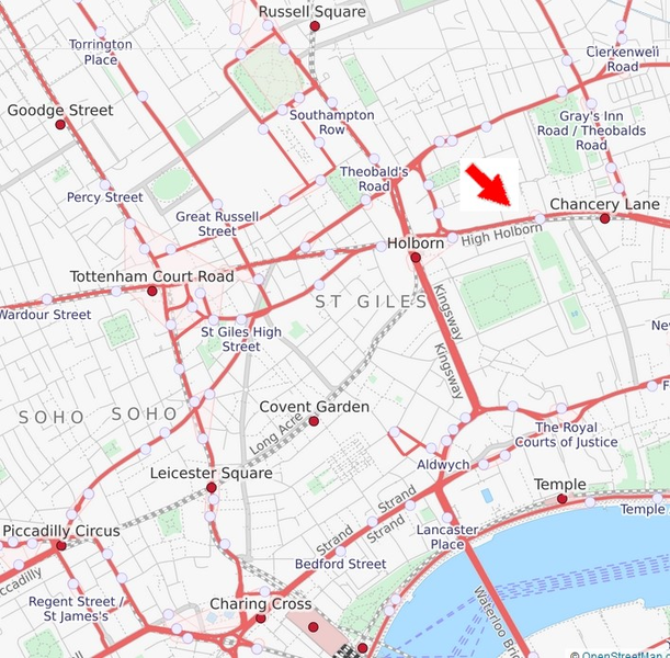
| Description | Map to show the location of The Penderel's Oak |
| Date | |
| Source | http://www.openstreetmap.org/#map=15/51.5153/-0.1268&layers=T |
| Author | Map created collaboratively at openstreetmap.org with post-rendering modifications by Philafrenzy |
| Permission (Reusing this file) |
CC-BY-SA-2.0 (see also OpenStreetMap license) |
| Other versions | The latest 'Live' version of this map is at: http://www.openstreetmap.org/#map=15/51.5153/-0.1268&layers=T OpenStreetMap also provides an API and various tools to access underlying raw data. This is a vector representation with geo locations, and including more details right down to postboxes and telephones, all of which can be rendered in alternative ways. |
This file is licensed under the Creative Commons Attribution-Share Alike 2.0 Generic license.
- You are free:
- to share – to copy, distribute and transmit the work
- to remix – to adapt the work
- Under the following conditions:
- attribution – You must give appropriate credit, provide a link to the license, and indicate if changes were made. You may do so in any reasonable manner, but not in any way that suggests the licensor endorses you or your use.
- share alike – If you remix, transform, or build upon the material, you must distribute your contributions under the same or compatible license as the original.
File history
Click on a date/time to view the file as it appeared at that time.
| Date/Time | Thumbnail | Dimensions | User | Comment | |
|---|---|---|---|---|---|
| current | 10:31, 14 January 2018 | | 708 × 695 (758 KB) | Philafrenzy | use transport version with bigger arrow for clarity |
| 16:58, 14 November 2010 |  | 515 × 479 (370 KB) | Jdforrester | Refreshed to use more modern map render style, and cover a slightly larger area. | |
| 14:18, 18 April 2008 |  | 330 × 322 (112 KB) | Harry Wood | {{Information |Description=Map to show the location of The Penderel's Oak |Source=http://openstreetmap.org |Date=18th April 2008 |Author=Map created collaboratively at openstreetmap.org with post-rendering modifications by Harry Wood |
File usage
The following 29 pages use this file:
- Meetup/London/174
- Meetup/London/175
- Meetup/London/176
- Meetup/London/177
- Meetup/London/178
- Meetup/London/179
- Meetup/London/180
- Meetup/London/181
- Meetup/London/182
- Meetup/London/183
- Meetup/London/184
- Meetup/London/185
- Meetup/London/186
- Meetup/London/187
- Meetup/London/188
- Meetup/London/189
- Meetup/London/190
- Meetup/London/191
- Meetup/London/192
- Meetup/London/193
- Meetup/London/194
- Meetup/London/195
- Meetup/London/196
- Meetup/London/197
- Meetup/London/198
- Meetup/London/199
- Meetup/London/200
- Meetup/London/201
- Meetup/London/202
Global file usage
The following other wikis use this file:
- Usage on en.wikipedia.org
- Wikipedia:Meetup/London/Template
- Wikipedia:Meetup/London 19
- Wikipedia:Meetup/London 20
- Wikipedia:Meetup/London 21
- Wikipedia:Meetup/London 22
- Wikipedia:Meetup/London 23
- Wikipedia:Meetup/London 24
- Wikipedia:Meetup/London 25
- Wikipedia:Meetup/London 26
- Wikipedia:Meetup/London 27
- Wikipedia:Meetup/London 28