
File:Thunder Bay ward map.svg

Size of this PNG preview of this SVG file: 545 × 600 pixels. Other resolutions: 218 × 240 pixels | 436 × 480 pixels | 698 × 768 pixels | 931 × 1,024 pixels | 1,862 × 2,048 pixels | 2,000 × 2,200 pixels.
Original file (SVG file, nominally 2,000 × 2,200 pixels, file size: 414 KB)
Summary
This W3C-unspecified vector image was created with Inkscape .
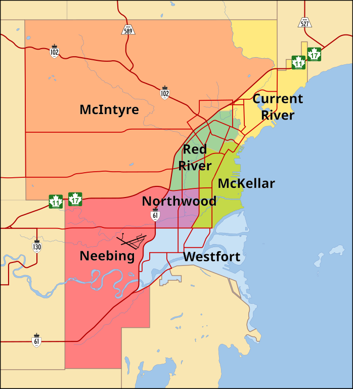
| Description | A map of Thunder Bay showing the seven municipal wards |
| Date | |
| Source | Trace of a satellite image from Google maps; City of Thunder Bay Ward Map |
| Author | Vidioman |
| Other versions | Image:Thunder Bay ward map.png |
Licensing
| I, the copyright holder of this work, release this work into the public domain. This applies worldwide. In some countries this may not be legally possible; if so: I grant anyone the right to use this work for any purpose, without any conditions, unless such conditions are required by law. |
File history
Click on a date/time to view the file as it appeared at that time.
| Date/Time | Thumbnail | Dimensions | User | Comment | |
|---|---|---|---|---|---|
| current | 03:06, 16 February 2008 | | 2,000 × 2,200 (414 KB) | Vidioman | |
| 02:11, 16 February 2008 |  | 2,000 × 2,200 (414 KB) | Vidioman | ||
| 11:25, 14 October 2007 |  | 2,000 × 2,200 (269 KB) | Vidioman | {{Created with Inkscape}} {{Information |Description=A map of Thunder Bay showing the seven municipal wards |Source=Trace of a satellite image from Google maps; City of Thunder Bay Ward Map |Date=14 October 2007 |Author= Vidioman |other_ |
File usage
There are no pages that use this file.
Global file usage
The following other wikis use this file:
- Usage on en.wikipedia.org
- Usage on ml.wikipedia.org
- Usage on nn.wikipedia.org
- Usage on sv.wikipedia.org