
File:FatuIva topographic map-fr.svg

Size of this PNG preview of this SVG file: 500 × 600 pixels. Other resolutions: 200 × 240 pixels | 400 × 480 pixels | 640 × 768 pixels | 853 × 1,024 pixels | 1,707 × 2,048 pixels | 750 × 900 pixels.
Original file (SVG file, nominally 750 × 900 pixels, file size: 414 KB)
Summary
| Description | |||
| Date | |||
| Source |
English: Own work.
Français : Own work.
|
||
| Author | Sémhur (talk) | ||
| Other versions |
|
||
| Attribution (required by the license) | © Sémhur / Wikimedia Commons / | ||
| SVG | W3C-validity not checked.
|
||
| Atelier graphique |

| Camera location | | View this and other nearby images on: OpenStreetMap |
|---|
Licensing
I, the copyright holder of this work, hereby publish it under the following licenses:
| Copyleft: This work of art is free; you can redistribute it and/or modify it according to terms of the Free Art License. You will find a specimen of this license on the Copyleft Attitude site as well as on other sites. |
This file is licensed under the Creative Commons Attribution-Share Alike 3.0 Unported, 2.5 Generic, 2.0 Generic and 1.0 Generic license.
- You are free:
- to share – to copy, distribute and transmit the work
- to remix – to adapt the work
- Under the following conditions:
- attribution – You must give appropriate credit, provide a link to the license, and indicate if changes were made. You may do so in any reasonable manner, but not in any way that suggests the licensor endorses you or your use.
- share alike – If you remix, transform, or build upon the material, you must distribute your contributions under the same or compatible license as the original.
You may select the license of your choice.
File history
Click on a date/time to view the file as it appeared at that time.
| Date/Time | Thumbnail | Dimensions | User | Comment | |
|---|---|---|---|---|---|
| current | 10:04, 19 August 2007 | | 750 × 900 (414 KB) | Sémhur | + road |
| 13:53, 8 August 2007 |  | 750 × 900 (171 KB) | Sémhur | + shaded relief | |
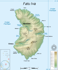
| 12:27, 8 August 2007 |  | 750 × 900 (168 KB) | Sémhur | == Description == {{en}} {{Information| |Description=Topographic map in French of the island of Fatu Hiva, Marquesas Islands, French Polynesia. |Source=Own work.{{clr}} Datas : * Background map : [http://www2.jpl.nasa.gov/srtm NASA Shutt |
File usage
There are no pages that use this file.
Global file usage
The following other wikis use this file:
- Usage on ca.wikipedia.org
- Usage on de.wikipedia.org
- Usage on en.wikipedia.org
- Usage on eo.wikipedia.org
- Usage on es.wikipedia.org
- Usage on fa.wikipedia.org
- Usage on fi.wikipedia.org
- Usage on fr.wikipedia.org
- Usage on gl.wikipedia.org
- Usage on he.wikipedia.org
- Usage on no.wikipedia.org
- Usage on pl.wikipedia.org