
File:Firehole river at Upper Geyser Basin-2008-june.jpg

Size of this preview: 800 × 575 pixels. Other resolutions: 320 × 230 pixels | 640 × 460 pixels | 1,024 × 736 pixels | 1,280 × 920 pixels | 2,100 × 1,509 pixels.
Original file (2,100 × 1,509 pixels, file size: 2.73 MB, MIME type: image/jpeg)
Summary
| Description |
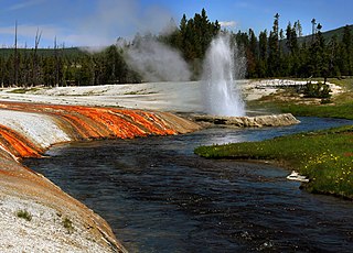
English: Cliff geyser and Iron Spring Creek at Black Sand Basin in Upper Geyser Basin in Yellowstone National Park
Français : Iron Spring Creek et Cliff geyser dans le Parc national de Yellowstone |
| Date | |
| Source | Own work |
| Author | Brocken Inaglory |
| Camera location | | View this and other nearby images on: OpenStreetMap |
|---|
Licensing
I, the copyright holder of this work, hereby publish it under the following licenses:
This file is licensed under the Creative Commons Attribution-Share Alike 3.0 Unported license.
- You are free:
- to share – to copy, distribute and transmit the work
- to remix – to adapt the work
- Under the following conditions:
- attribution – You must give appropriate credit, provide a link to the license, and indicate if changes were made. You may do so in any reasonable manner, but not in any way that suggests the licensor endorses you or your use.
- share alike – If you remix, transform, or build upon the material, you must distribute your contributions under the same or compatible license as the original.

|
Permission is granted to copy, distribute and/or modify this document under the terms of the GNU Free Documentation License, Version 1.2 or any later version published by the Free Software Foundation; with no Invariant Sections, no Front-Cover Texts, and no Back-Cover Texts. A copy of the license is included in the section entitled GNU Free Documentation License. |
You may select the license of your choice.
Assessment
|

This image was selected as picture of the day on Wikimedia Commons for 5 July 2009. It was captioned as follows: English: Cliff Geyser and Firehole River at Black Sand Basin in Upper Geyser Basin in Yellowstone National Park. Other languages:
Dansk: Cliff-gejseren og floden Firehole River ved Black Sand Basin i det øvre gejserbassin i Yellowstone National Park. English: Cliff Geyser and Firehole River at Black Sand Basin in Upper Geyser Basin in Yellowstone National Park. Italiano: Il Cliff Geyser e il Firehole River presso il Black Sand Basin nel Parco nazionale di Yellowstone, Stati Uniti. Nederlands: De geiser Cliff bij de rivier de Firehole in Black Sand, een geïsoleerde groep geisers van de Upper Geyser Basin in het Amerikaanse nationaal park Yellowstone. Polski: Gejzer klifowy i rzeka Firehole w niecce gejzerowej Black Sand w Parku Narodowym Yellowstone, Stany Zjednoczone. Македонски: Клифскиот гејзер и реката Фајрхол во басенот Блек Сенд во Горниот гејзерски басен во националниот парк Јелоустоун, САД. 中文: 美国黄石国家公园上间歇泉盆地黑砂盆地悬崖间歇泉及火洞河。 |
File history
Click on a date/time to view the file as it appeared at that time.
| Date/Time | Thumbnail | Dimensions | User | Comment | |
|---|---|---|---|---|---|
| current | 19:40, 23 April 2009 | | 2,100 × 1,509 (2.73 MB) | Mbz1 | corrected color balance |
| 19:10, 23 April 2009 |  | 2,100 × 1,509 (2.72 MB) | Mbz1 | reduced noise | |
| 19:01, 23 April 2009 |  | 2,100 × 1,509 (2.72 MB) | Mbz1 | corrected color balance | |
| 18:51, 23 April 2009 |  | 2,100 × 1,509 (2.62 MB) | Mbz1 | {{Information |Description={{en|1=Firehole river at Upper Geyser Basin}} |Source=Own work by uploader |Author=Mbz1 |Date= |Permission= |other_versions= }} <!--{{ImageUpload|full}}--> |
File usage
The following page uses this file:
Global file usage
The following other wikis use this file:
- Usage on bn.wikipedia.org
- Usage on ceb.wikipedia.org
- Usage on crh.wikipedia.org
- Usage on cv.wikipedia.org
- Usage on da.wikipedia.org
- Usage on de.wikipedia.org
- Usage on de.wikivoyage.org
- Usage on en.wikipedia.org
- Usage on eo.wikipedia.org
- Usage on eu.wikipedia.org
- Usage on fi.wikipedia.org
- Usage on fr.wikipedia.org
- Usage on fr.wikiversity.org
- Usage on hu.wikipedia.org
- Usage on ko.wikipedia.org
- Usage on lbe.wikipedia.org
- Usage on mg.wikipedia.org
- Usage on mk.wikipedia.org
- Usage on nl.wikivoyage.org
- Usage on os.wikipedia.org
- Usage on pl.wikipedia.org
- Usage on pt.wikipedia.org
- Usage on ru.wikipedia.org
- Usage on ru.wikinews.org
- Usage on ru.wikivoyage.org
- Usage on sah.wikipedia.org
- Usage on sr.wikipedia.org
- Usage on sv.wikipedia.org
- Usage on tr.wikipedia.org
- Usage on uk.wikipedia.org
- Usage on vi.wikipedia.org
- Usage on www.wikidata.org
- Usage on xal.wikipedia.org
- Usage on zh.wikipedia.org