
File:France ESA379527.jpg

Original file (4,526 × 4,716 pixels, file size: 30.62 MB, MIME type: image/jpeg)
Summary
| Description |
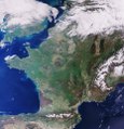
English: Sentinel-3 gives us a nearly cloud-free view of France and the surrounding countries.
Much of the landscape is covered with agricultural features. In fact, farmers manage nearly half of Europe’s land area. While agriculture brings benefits for economy and food security, it puts the environment under pressure. Satellites can help to map and monitor land use, and the information they provide can be used to improve agricultural practices. On the right side of the image we can see the snow-covered Alps, while the Pyrenees mountains are visible near the bottom. To the west of the Alps a green area of mountains and plateaus is visible, called the Massif Central. The region has more than 400 volcanoes, considered by scientists to be extinct. On the right side of the image, the light brown area flanked by dark areas is the Rhine River forming part of France’s border with Germany. The dark area to the east is the Black Forest, while the dark area to the west are the Vosges Mountains. Just above the centre we can see Paris – the site of ESA’s headquarters as well as the Paris Air & Space Show taking place this week. This image was captured by the Copernicus Sentinel-3A satellite’s Ocean and Land Colour Instrument on 7 April 2017. The instrument monitors ocean ecosystems, supports crop management and agriculture, and provides estimates of atmospheric aerosol and clouds – all of which bring significant benefits through more informed decision-making. |
| Date | |
| Source | http://www.esa.int/spaceinimages/Images/2017/06/France |
| Author | European Space Agency |
| Permission (Reusing this file) |
contains modified Copernicus Sentinel data (2017), processed by ESA,CC BY-SA 3.0 IGO |
| Other versions |
|
| Title | France |
| Set | Earth observation image of the week |
| System | Copernicus |
| Mission | Sentinel-3 |
| Location | France |
| Activity | Observing the Earth |
| Keywords | Agriculture; Mountain; Satellite image |
Licensing
- You are free:
- to share – to copy, distribute and transmit the work
- to remix – to adapt the work
- Under the following conditions:
- attribution – You must give appropriate credit, provide a link to the license, and indicate if changes were made. You may do so in any reasonable manner, but not in any way that suggests the licensor endorses you or your use.
- share alike – If you remix, transform, or build upon the material, you must distribute your contributions under the same or compatible license as the original.

|
This image contains data from a satellite in the Copernicus Programme, such as Sentinel-1, Sentinel-2 or Sentinel-3. Attribution is required when using this image.
Attribution: Contains modified Copernicus Sentinel data {{{year}}}
The use of Copernicus Sentinel Data is regulated under EU law (Commission Delegated Regulation (EU) No 1159/2013 and Regulation (EU) No 377/2014). Relevant excerpts:
Free access shall be given to GMES dedicated data [...] made available through GMES dissemination platforms [...].
Access to GMES dedicated data [...] shall be given for the purpose of the following use in so far as it is lawful:
GMES dedicated data [...] may be used worldwide without limitations in time.
GMES dedicated data and GMES service information are provided to users without any express or implied warranty, including as regards quality and suitability for any purpose. |
File history
Click on a date/time to view the file as it appeared at that time.
| Date/Time | Thumbnail | Dimensions | User | Comment | |
|---|---|---|---|---|---|
| current | 23:55, 2 January 2021 | | 4,526 × 4,716 (30.62 MB) | StellarHalo | higher resolution |
| 10:57, 28 June 2017 |  | 1,920 × 2,001 (4.33 MB) | Fæ | European Space Agency, Id 379527, http://www.esa.int/spaceinimages/Images/2017/06/France, User:Fæ/Project_list/ESA |
File usage
The following page uses this file:
Global file usage
The following other wikis use this file:
- Usage on en.wikipedia.org
- Usage on www.wikidata.org