
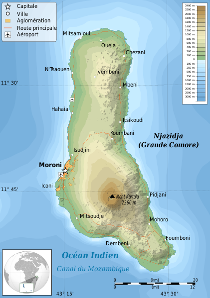
File:Grande Comore topographic map-fr.svg

Size of this PNG preview of this SVG file: 421 × 599 pixels. Other resolutions: 168 × 240 pixels | 337 × 480 pixels | 539 × 768 pixels | 719 × 1,024 pixels | 1,439 × 2,048 pixels | 1,200 × 1,708 pixels.
Original file (SVG file, nominally 1,200 × 1,708 pixels, file size: 1.31 MB)
Summary
| Description |
UTM projection, WGS84 datum
|
| Date | |
| Source |
Own work
|
| Author | Ikonact |
| Other versions |
|

Licensing
I, the copyright holder of this work, hereby publish it under the following licenses:
This file is licensed under the Creative Commons Attribution-Share Alike 3.0 Unported license.
- You are free:
- to share – to copy, distribute and transmit the work
- to remix – to adapt the work
- Under the following conditions:
- attribution – You must give appropriate credit, provide a link to the license, and indicate if changes were made. You may do so in any reasonable manner, but not in any way that suggests the licensor endorses you or your use.
- share alike – If you remix, transform, or build upon the material, you must distribute your contributions under the same or compatible license as the original.

|
Permission is granted to copy, distribute and/or modify this document under the terms of the GNU Free Documentation License, Version 1.2 or any later version published by the Free Software Foundation; with no Invariant Sections, no Front-Cover Texts, and no Back-Cover Texts. A copy of the license is included in the section entitled GNU Free Documentation License. |
You may select the license of your choice.
File history
Click on a date/time to view the file as it appeared at that time.
| Date/Time | Thumbnail | Dimensions | User | Comment | |
|---|---|---|---|---|---|
| current | 12:52, 26 October 2011 | | 1,200 × 1,708 (1.31 MB) | Ikonact | corrected issue with borders |
| 07:15, 15 October 2011 |  | 1,200 × 1,708 (1.4 MB) | Ikonact | {{Information |Description ={{en|1=Topographic map of Grande Comore,Comoros }} {{fr|1=Carte topographiaue Grande Comore,Archipel des Comores}} UTM projection, |
File usage
There are no pages that use this file.
Global file usage
The following other wikis use this file:
- Usage on ar.wikipedia.org
- Usage on arz.wikipedia.org
- Usage on ast.wikipedia.org
- Usage on az.wikipedia.org
- Usage on be.wikipedia.org
- Usage on ca.wikipedia.org
- Usage on es.wikipedia.org
- Usage on eu.wikipedia.org
- Usage on fr.wikipedia.org
- Usage on gl.wikipedia.org
- Usage on ha.wikipedia.org
- Usage on it.wikipedia.org
- Usage on it.wikivoyage.org
- Usage on ja.wikipedia.org
- Usage on mg.wikipedia.org
- Usage on mk.wikipedia.org
- Usage on nl.wikipedia.org
- Usage on pl.wikipedia.org
- Usage on ru.wikipedia.org
- Usage on sk.wikipedia.org
- Usage on uk.wikipedia.org
- Usage on www.wikidata.org