
File:Ireland geographical map.png
No higher resolution available.
Ireland_geographical_map.png (150 × 190 pixels, file size: 50 KB, MIME type: image/png)
| Description |
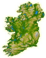
English: Topography of Ireland |
| Date | IotD Date 2005-03-18 |
| Source |
NASA: IotD ID 16853 – http://visibleearth.nasa.gov/view_rec.php?id=17124 |
| Author | NASA, see Image:Topography Ireland.jpg for more information |
| Permission (Reusing this file) |
public domain |
| Other versions | original, bigger version at Image:Topography Ireland.jpg |
| This file is in the public domain in the United States because it was solely created by NASA. NASA copyright policy states that "NASA material is not protected by copyright unless noted". (See Template:PD-USGov, NASA copyright policy page or JPL Image Use Policy.) | ||
 |
Warnings:
|
File history
Click on a date/time to view the file as it appeared at that time.
| Date/Time | Thumbnail | Dimensions | User | Comment | |
|---|---|---|---|---|---|
| current | 11:39, 11 July 2005 | | 150 × 190 (50 KB) | Kanchelskis | Map of Ireland lightened. Author:me {{GFDL}} Category: Ireland |
File usage
There are no pages that use this file.
Global file usage
The following other wikis use this file:
- Usage on de.wikipedia.org
- Usage on en.wikipedia.org
- User:Jtdirl
- User:Kwekubo
- Dingle Peninsula
- User:Zoney
- Iveragh Peninsula
- User:Ropers
- User:Gerry Lynch
- User:AndrewH
- User:Ebelular
- Inishowen
- User:Fergananim
- Mizen Head
- Sheep's Head
- Old Head of Kinsale
- User:Rye 212
- Ards Peninsula
- User:Blorg
- User:Wexfordman
- User:Meabhar~enwiki
- Howth Head
- User:Sean3000
- User:Notjim
- User:Jasonm
- User:Kgaughan
- Beara Peninsula
- User:John Carroll
- User:Bjimba
- User talk:Lochaber
- Fanad
- User:Hetch
- Islandmagee
- User:Wikipedian231
- User:Jdorney
- User:Merlante
- User:Lugnad
- Slieve League
- User:Ben-w
- Hook Peninsula
- User:Polar ice
- User:Dowlingm
- User:Frure
- User:Ventolin
- User:Dkie
- User:Colm Rice
- Mullaghmore, County Sligo
- User:Damac
- User:Ian Cheese
- User:Tpower
- User:Raemie
View more global usage of this file.