
File:Iroise sea map-fr.svg

Size of this PNG preview of this SVG file: 537 × 600 pixels. Other resolutions: 215 × 240 pixels | 430 × 480 pixels | 687 × 768 pixels | 916 × 1,024 pixels | 1,833 × 2,048 pixels | 776 × 867 pixels.
Original file (SVG file, nominally 776 × 867 pixels, file size: 406 KB)
Summary
| Camera location | | View this and other nearby images on: OpenStreetMap |
|---|
| Description |
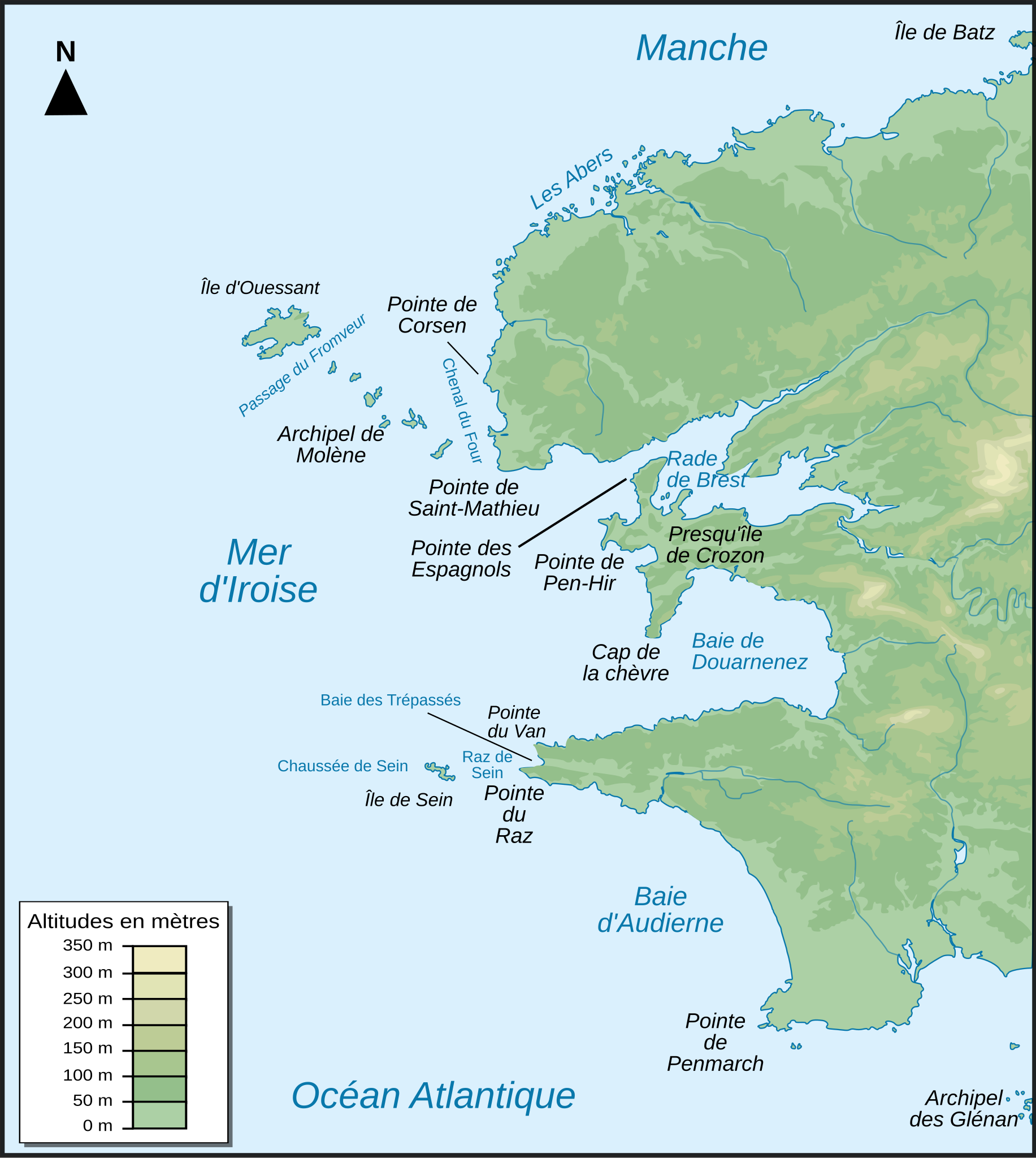
Français : Carte topographique du Finistère et de la mer d'Iroise en France : version française
English: Topographic map of Finistère in France and iroise sea : french version |
| Date | |
| Source |
Own work Topographic map : NASA Shuttle Radar Topography Mission (SRTM3 v.2) (public domain) edited with dlgv32 Pro and vectorized with Inkscape ; UTM projection ; WGS84 datum ; |
| Author | Pinpin |
| Other versions |
|


|
This SVG file contains embedded text that can be translated into your language, using any capable SVG editor, text editor or the SVG Translate tool. For more information see: About translating SVG files. |
Licensing
I, the copyright holder of this work, hereby publish it under the following licenses:

|
Permission is granted to copy, distribute and/or modify this document under the terms of the GNU Free Documentation License, Version 1.2 or any later version published by the Free Software Foundation; with no Invariant Sections, no Front-Cover Texts, and no Back-Cover Texts. A copy of the license is included in the section entitled GNU Free Documentation License. |
This file is licensed under the Creative Commons Attribution-Share Alike 3.0 Unported, 2.5 Generic, 2.0 Generic and 1.0 Generic license.
- You are free:
- to share – to copy, distribute and transmit the work
- to remix – to adapt the work
- Under the following conditions:
- attribution – You must give appropriate credit, provide a link to the license, and indicate if changes were made. You may do so in any reasonable manner, but not in any way that suggests the licensor endorses you or your use.
- share alike – If you remix, transform, or build upon the material, you must distribute your contributions under the same or compatible license as the original.
You may select the license of your choice.
File history
Click on a date/time to view the file as it appeared at that time.
| Date/Time | Thumbnail | Dimensions | User | Comment | |
|---|---|---|---|---|---|
| current | 22:29, 4 December 2007 | | 776 × 867 (406 KB) | Korrigan | typo |
| 17:12, 4 December 2007 |  | 776 × 867 (406 KB) | Pinpin | labels in italic | |
| 17:10, 4 December 2007 |  | 776 × 867 (406 KB) | Pinpin | add labels | |
| 20:00, 3 December 2007 |  | 776 × 867 (411 KB) | Pinpin | ||
| 19:58, 3 December 2007 |  | 776 × 867 (411 KB) | Pinpin | {{Information |Description={{fr|Carte topographique du Finistère et de la mer d'Iroise en France : version française}} {{en|Topographic map of Finistère in France and iroise sea : french version}} |Source=Own work <br/>Topographic map : [http://www2.jp |
File usage
There are no pages that use this file.
Global file usage
The following other wikis use this file:
- Usage on az.wikipedia.org
- Usage on ca.wikipedia.org
- Usage on cy.wikipedia.org
- Usage on da.wikipedia.org
- Usage on de.wikipedia.org
- Usage on el.wikipedia.org
- Usage on en.wikipedia.org
- Usage on eo.wikipedia.org
- Usage on es.wikipedia.org
- Usage on frr.wikipedia.org
- Usage on fr.wikipedia.org
- Pointe de Corsen
- Pointe du Raz
- Côte des Abers
- Baie des Trépassés
- Presqu'île de Crozon
- Baie d'Audierne
- Wikipédia:Atelier graphique/Cartes/Archives/août 2008
- Wikipédia:Atelier graphique/Cartes/Archives/septembre 2008
- Projet:Impression/Wikigraphistes
- Parc naturel marin d'Iroise
- Wikipédia:Atelier graphique/Cartes/Archives/Demandes mises en sommeil/Monde
- Usage on fr.wiktionary.org
- Usage on is.wikipedia.org
- Usage on it.wikipedia.org
View more global usage of this file.