
File:Map of Еastern Thrace borders Bulgaria Ottoman empire 1912 1919-bg.svg

Size of this PNG preview of this SVG file: 671 × 599 pixels. Other resolutions: 269 × 240 pixels | 537 × 480 pixels | 860 × 768 pixels | 1,146 × 1,024 pixels | 2,292 × 2,048 pixels | 1,679 × 1,500 pixels.
Original file (SVG file, nominally 1,679 × 1,500 pixels, file size: 10.55 MB)
Summary
| Description |
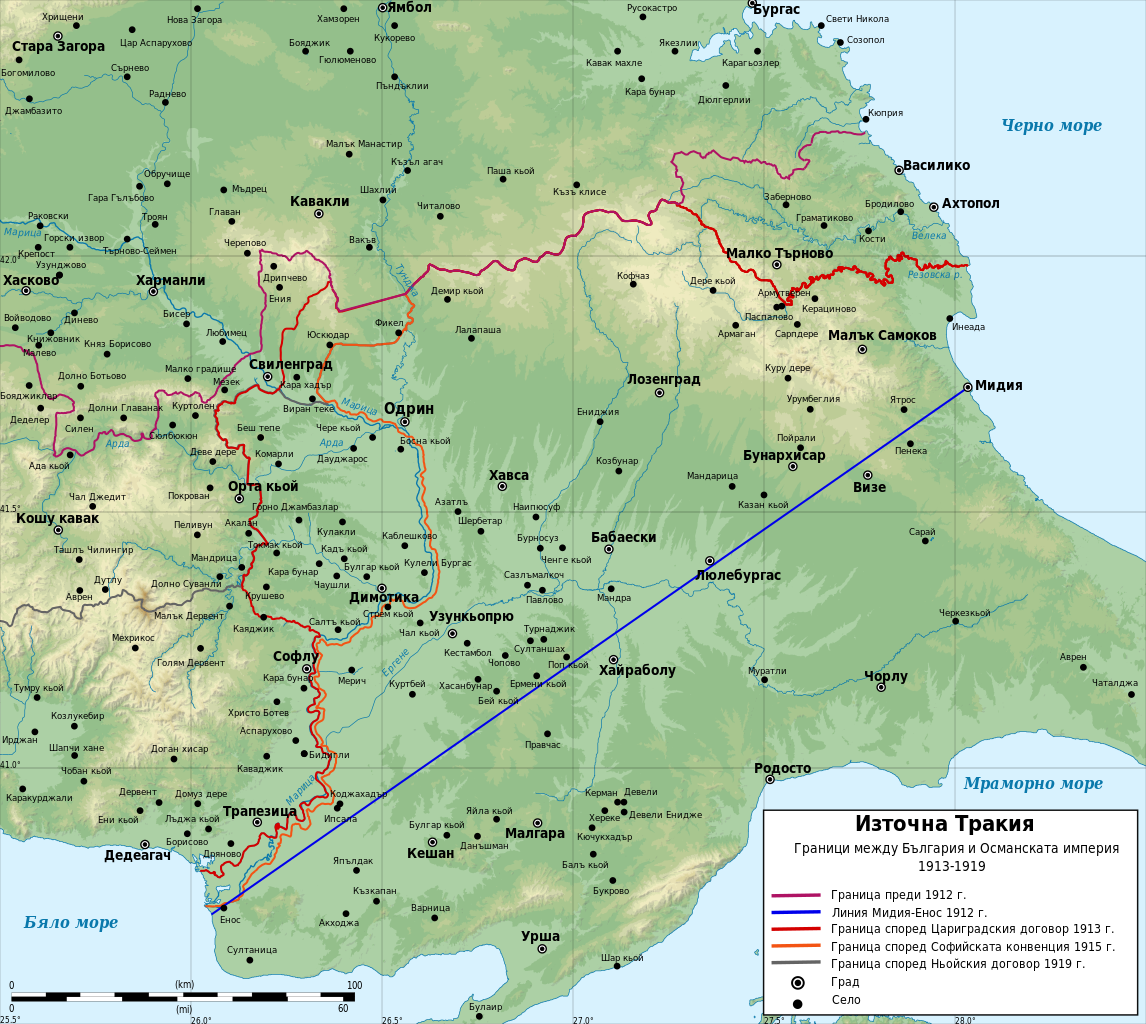
English: Historical map of borders between Bulgaria and Ottoman Empire in Eastern Thrace between 1912 and 1919. In Bulgarian
Български: Историческа Карта на Източна Тракия с границите между България и Османската империя между 1912 и 1919 г. На български
Мар information:
|
| Date | |
| Source |
Own work Data:
|
| Author | Ikonact |
Licensing
I, the copyright holder of this work, hereby publish it under the following licenses:
This file is licensed under the Creative Commons Attribution-Share Alike 3.0 Unported license.
- You are free:
- to share – to copy, distribute and transmit the work
- to remix – to adapt the work
- Under the following conditions:
- attribution – You must give appropriate credit, provide a link to the license, and indicate if changes were made. You may do so in any reasonable manner, but not in any way that suggests the licensor endorses you or your use.
- share alike – If you remix, transform, or build upon the material, you must distribute your contributions under the same or compatible license as the original.

|
Permission is granted to copy, distribute and/or modify this document under the terms of the GNU Free Documentation License, Version 1.2 or any later version published by the Free Software Foundation; with no Invariant Sections, no Front-Cover Texts, and no Back-Cover Texts. A copy of the license is included in the section entitled GNU Free Documentation License. |
You may select the license of your choice.
File history
Click on a date/time to view the file as it appeared at that time.
| Date/Time | Thumbnail | Dimensions | User | Comment | |
|---|---|---|---|---|---|
| current | 21:41, 9 January 2024 | | 1,679 × 1,500 (10.55 MB) | Ikonact | Further correction of the 1915 border near Enos |
| 21:10, 9 January 2024 |  | 1,679 × 1,500 (10.55 MB) | Ikonact | Correction of teh 1915 border | |
| 07:06, 8 March 2014 |  | 1,679 × 1,500 (10.55 MB) | Ikonact | {{Information |Description ={{en|1=Historical map of borders between Bulgaria and Ottoman Empire in Eastern Thrace between 1912 and 1919. In Bulgarian}} {{bg|1=Историческа Карта на [[:bg:Източна Тра... |
File usage
There are no pages that use this file.
Global file usage
The following other wikis use this file:
- Usage on bg.wikipedia.org
- Usage on ru.wikipedia.org
- Usage on tr.wikipedia.org