
File:Slavo serbia location map.png

Size of this preview: 433 × 599 pixels. Other resolutions: 173 × 240 pixels | 347 × 480 pixels | 555 × 768 pixels | 740 × 1,024 pixels | 1,573 × 2,176 pixels.
Original file (1,573 × 2,176 pixels, file size: 110 KB, MIME type: image/png)
Summary
| Description |
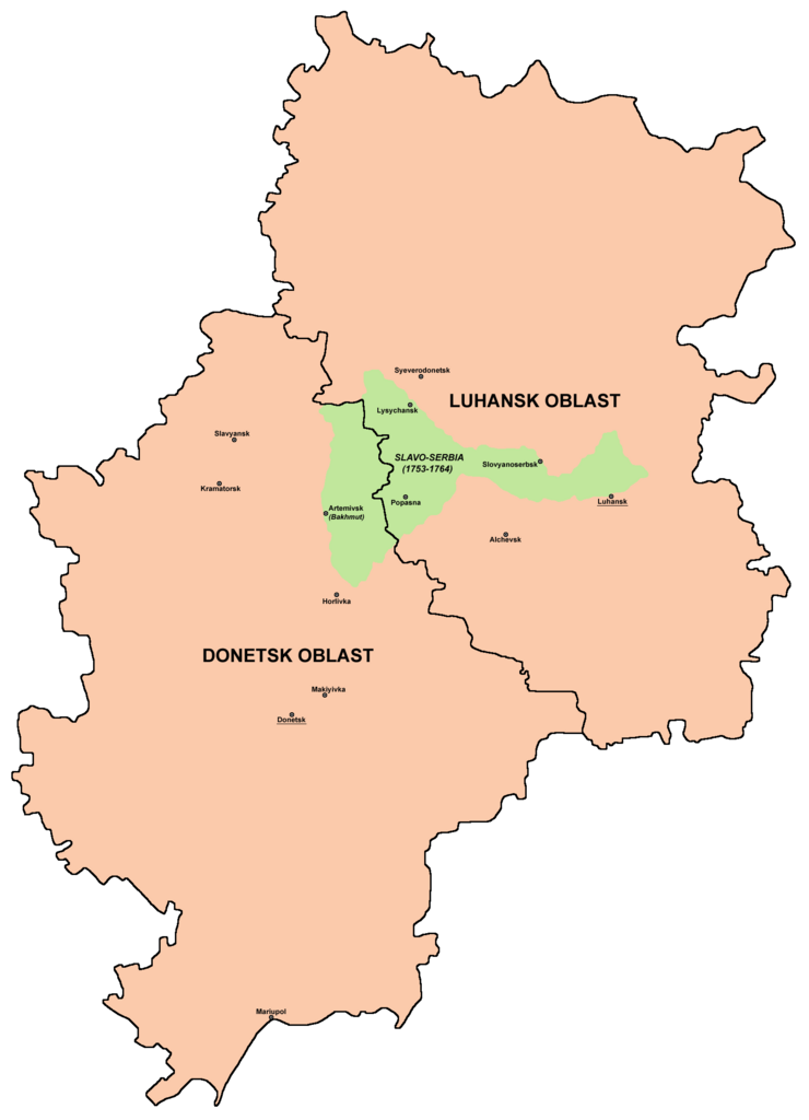
English: Borders of historical Slavo-Serbia (1753-1764) compared with borders of modern Luhansk Oblast and Donetsk Oblast of Ukraine. Српски / srpski: Granice istorijske Slavenosrbije (1753-1764) upoređene sa granicama današnje Luganske oblasti i Donjecke oblasti u Ukrajini. |
| Date | |
| Source | Own work |
| Author | PANONIAN |
Licensing
| I, the copyright holder of this work, release this work into the public domain. This applies worldwide. In some countries this may not be legally possible; if so: I grant anyone the right to use this work for any purpose, without any conditions, unless such conditions are required by law. |
References
- Mita Kostić, Nova Srbija i Slavenosrbija, Novi Sad, 2001.
- Olga M. Posunjko, Istorija Nove Srbije i Slavenosrbije, Novi Sad, 2002.
- Pavel Rudjakov, Seoba Srba u Rusiju u 18. veku, Beograd, 1995.
- http://www.rastko.rs/rastko-ukr/istorija/img/sloveno_serbija.jpg
- http://www.irekw.internetdsl.pl/27_1727-1768.jpg
- http://www.jewishgen.org/Ukraine/maps/Ukrainian-Land-1750.jpg
- http://ua.all-biz.info/img/regions/pic/25_16_radm_955383044.gif
- http://ukrgr.net/files/images/luganskaja-02.gif
- http://ukrindustrial.com/img/regions/pic/24_16_radm_358268491.gif
- http://www.rada.gov.ua/~dtrp/data/obl/don.jpg
File history
Click on a date/time to view the file as it appeared at that time.
| Date/Time | Thumbnail | Dimensions | User | Comment | |
|---|---|---|---|---|---|
| current | 19:33, 2 May 2010 | | 1,573 × 2,176 (110 KB) | PANONIAN | {{Information |Description={{en|1=Borders of historical Slavo-Serbia (1753-1764) compared with borders of modern Luhansk Oblast and Donetsk Oblast of Ukraine.}} |Source={{own}} |Author=PANONIAN |Date= |Permission= |other_versions= }} |
File usage
There are no pages that use this file.
Global file usage
The following other wikis use this file:
- Usage on bg.wikipedia.org
- Usage on de.wikipedia.org
- Usage on fr.wikipedia.org
- Usage on it.wikipedia.org
- Usage on lv.wikipedia.org
- Usage on pl.wikipedia.org
- Usage on ru.wikipedia.org
- Usage on sh.wikipedia.org
- Usage on sq.wikipedia.org
- Usage on uk.wikipedia.org
- Usage on vi.wikipedia.org