
File:Torino mappa.png
Size of this preview: 698 × 599 pixels. Other resolutions: 280 × 240 pixels | 559 × 480 pixels | 750 × 644 pixels.
Original file (750 × 644 pixels, file size: 263 KB, MIME type: image/png)
Summary
| Description |
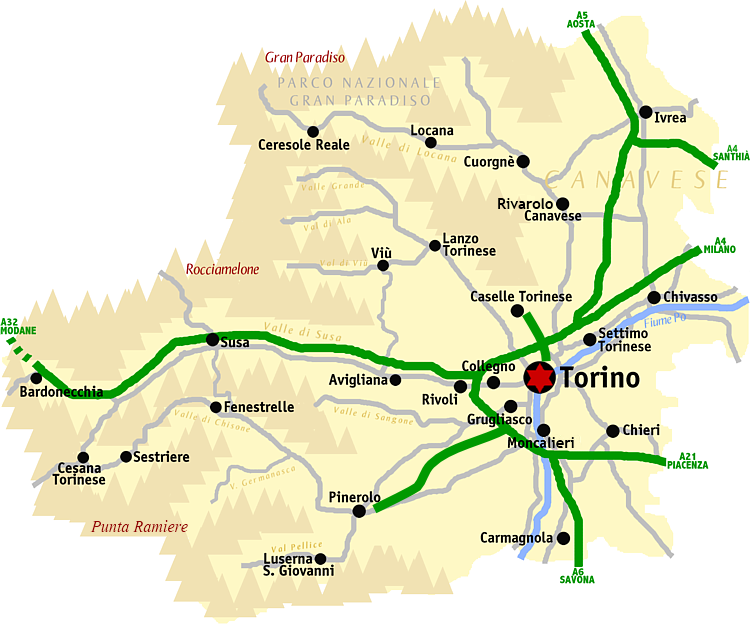
Italiano: Mappa della provincia di Torino
Nederlands: Kaart van de provincie Turijn |
| Date | 4 September 2005 (original upload date) |
| Source | Transferred from nl.wikipedia to Commons. |
| Author | Idéfix at Dutch Wikipedia |
Licensing
Idéfix at Dutch Wikipedia, the copyright holder of this work, hereby publishes it under the following license:

|
Permission is granted to copy, distribute and/or modify this document under the terms of the GNU Free Documentation License, Version 1.2 or any later version published by the Free Software Foundation; with no Invariant Sections, no Front-Cover Texts, and no Back-Cover Texts. A copy of the license is included in the section entitled GNU Free Documentation License. |
| This file is licensed under the Creative Commons Attribution-Share Alike 3.0 Unported license. | ||
| Attribution: Idéfix at Dutch Wikipedia | ||
| ||
| This licensing tag was added to this file as part of the GFDL licensing update. |
File history
Click on a date/time to view the file as it appeared at that time.
| Date/Time | Thumbnail | Dimensions | User | Comment | |
|---|---|---|---|---|---|
| current | 14:56, 14 January 2015 | | 750 × 644 (263 KB) | Gigillo83 | + A55 e RA10 |
| 13:59, 18 July 2012 |  | 750 × 644 (226 KB) | ANGELUS | Bric Froid ---> Punta Ramiere | |
| 13:43, 18 July 2012 |  | 750 × 644 (227 KB) | ANGELUS | fixed | |
| 17:03, 10 December 2009 |  | 750 × 644 (244 KB) | AlMare | Fixed 'Fenestrelle' | |
| 22:32, 12 December 2007 |  | 750 × 644 (294 KB) | BotMultichill | {{BotMoveToCommons|nl.wikipedia}} {{Information |Description={{nl|Kaart van de provincie Turijn}} |Source=Transfered from [http://nl.wikipedia.org nl.wikipedia] |Date=2005-09-04 (original upload date) |Author=Original uploader was [[:nl:User:Idéfix|Id� |
File usage
The following page uses this file:
Global file usage
The following other wikis use this file:
- Usage on ar.wikipedia.org
- Usage on ast.wikipedia.org
- Usage on az.wikipedia.org
- Usage on be.wikipedia.org
- Usage on bg.wikipedia.org
- Usage on br.wikipedia.org
- Usage on cs.wikipedia.org
- Usage on de.wikipedia.org
- Usage on en.wikipedia.org
- Usage on eo.wikivoyage.org
- Usage on es.wikipedia.org
- Usage on et.wikipedia.org
- Usage on frr.wikipedia.org
- Usage on fr.wikipedia.org
- Usage on fy.wikipedia.org
- Usage on gl.wikipedia.org
- Usage on hu.wikipedia.org
- Usage on hy.wikipedia.org
- Usage on id.wikipedia.org
- Usage on it.wikipedia.org
- Usage on ja.wikipedia.org
- Usage on jv.wikipedia.org
- Usage on ka.wikipedia.org
- Usage on ko.wikipedia.org
- Usage on lij.wikipedia.org
- Usage on ms.wikipedia.org
- Usage on nap.wikipedia.org
- Usage on nds.wikipedia.org
- Usage on nl.wikipedia.org
- Usage on nn.wikipedia.org
- Usage on no.wikipedia.org
- Usage on pt.wikipedia.org
View more global usage of this file.