
File:Baldy Hill from Snowslide Valley, Craigieburn Range, Canterbury, New Zealand.jpg

Size of this preview: 800 × 344 pixels. Other resolutions: 320 × 138 pixels | 640 × 275 pixels | 1,024 × 440 pixels | 1,280 × 551 pixels | 2,560 × 1,101 pixels | 9,664 × 4,157 pixels.
Original file (9,664 × 4,157 pixels, file size: 29.53 MB, MIME type: image/jpeg)
Summary
| Description |
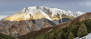
English: Baldy Hill from Snowslide Valley, Craigieburn Range, Canterbury, New Zealand
Français : Le pic Baldy Hill situé dans la chaîne Craigieburn (Alpes du Sud, Canterbury, Nouvelle-Zélande).
Magyar: A Baldy Hill látképe a Snowslide Valley felől (Craigieburn hegylánc, Canterbury régió, Új-Zéland)
Македонски: Ридот Болди во венецот Крејгиберн. Кантербери, Нов Зеланд.
Português: Panorama de Baldy Hill visto do Snowslide Valley, Craigieburn Range, Canterbury, Nova Zelândia
Українська: Вигляд гори Болді-Гілл (1834 м) із долини Сновслайд, хребет Крейґібурн, Кентербері, Нова Зеландія
বাংলা: স্নোস্লাইড উপত্যকা থেকে বাল্ডি পাহাড়, ক্রেইগিবার্ন রেঞ্জ, ক্যান্টারবেরি, নিউজিল্যান্ড।
Эрзянь: Baldy Hill пандтне Ловпандонь Лашмосонть (Snowslide Valley), Craigieburn Range, Кентербери, Од Зеландия. |
| Date | |
| Source | Own work |
| Author | Michal Klajban |
| Camera location | | View this and other nearby images on: OpenStreetMap |
|---|
| Object location | | View this and other nearby images on: OpenStreetMap |
|---|
Assessment
|
This image was selected as picture of the day on Wikimedia Commons for 2 December 2020. It was captioned as follows: Other languages:
Čeština: Hora Baldy Hill z údolí Snowslide Valley v pohoří Craigieburn Range v oblasti Canterbury na Novém Zélandu. Français : Le pic Baldy Hill situé dans la chaîne Craigieburn (Alpes du Sud, Canterbury, Nouvelle-Zélande). Magyar: A Baldy Hill látképe a Snowslide Valley felől (Craigieburn hegylánc, Canterbury régió, Új-Zéland) Português: Panorama de Baldy Hill visto do Snowslide Valley, Craigieburn Range, Canterbury, Nova Zelândia Македонски: Ридот Болди во венецот Крејгиберн. Кантербери, Нов Зеланд. Українська: Гора Болді-Гілл (1834 м) із долини Сновслайд, хребет Крейґібурн, Кентербері, Нова Зеландія বাংলা : স্নোস্লাইড উপত্যকা থেকে বাল্ডি পাহাড়, ক্রেইগিবার্ন রেঞ্জ, ক্যান্টারবেরি, নিউজিল্যান্ড। العربية : مرتفعات بالدي من وادي سنوسلايد في سلسلة كرايغينبيرن، في كانتربوري في نيوزيلندا |
This image has been assessed using the Quality image guidelines and is considered a Quality image.
|
The production, editing or release of this file was supported by the Community-Budget of Wikimedia Deutschland. To see other files made with the support of Wikimedia Deutschland, please see the category Supported by Wikimedia Deutschland. |
Licensing
I, the copyright holder of this work, hereby publish it under the following license:
This file is licensed under the Creative Commons Attribution-Share Alike 4.0 International license.
- You are free:
- to share – to copy, distribute and transmit the work
- to remix – to adapt the work
- Under the following conditions:
- attribution – You must give appropriate credit, provide a link to the license, and indicate if changes were made. You may do so in any reasonable manner, but not in any way that suggests the licensor endorses you or your use.
- share alike – If you remix, transform, or build upon the material, you must distribute your contributions under the same or compatible license as the original.
File history
Click on a date/time to view the file as it appeared at that time.
| Date/Time | Thumbnail | Dimensions | User | Comment | |
|---|---|---|---|---|---|
| current | 20:37, 21 July 2019 | | 9,664 × 4,157 (29.53 MB) | Podzemnik | going back to more highlights into the sunny area |
| 21:29, 14 July 2019 |  | 9,664 × 4,157 (29.49 MB) | Podzemnik | tiny crop from the top | |
| 21:15, 14 July 2019 |  | 9,664 × 4,364 (30.08 MB) | Podzemnik | less highlights in the bright area, tiny crop from the left | |
| 21:35, 5 July 2019 |  | 9,803 × 4,148 (29.34 MB) | Podzemnik | User created page with UploadWizard |
File usage
There are no pages that use this file.
Global file usage
The following other wikis use this file:
- Usage on av.wikipedia.org
- Usage on be-tarask.wikipedia.org
- Usage on bn.wikipedia.org
- Usage on crh.wikipedia.org
- Usage on cv.wikipedia.org
- Usage on en.wikipedia.org
- Usage on es.wikipedia.org
- Usage on hu.wikipedia.org
- Usage on hy.wikipedia.org
- Usage on it.wikipedia.org
- Usage on ja.wikipedia.org
- Usage on ka.wikipedia.org
- Usage on ko.wikipedia.org
- Usage on lbe.wikipedia.org
- Usage on lez.wikipedia.org
- Usage on mg.wikipedia.org
- Usage on mk.wikipedia.org
- Usage on os.wikipedia.org
- Usage on pt.wikipedia.org
- Usage on ru.wikipedia.org
- Usage on ru.wikinews.org
- Usage on sah.wikipedia.org
- Usage on sv.wikipedia.org
- Usage on tt.wikipedia.org
- Usage on vep.wikipedia.org
- Usage on www.wikidata.org
- Usage on zh.wikipedia.org