WMDE Technical Wishes/Geoinformation/Summary of the Kartographer survey
Key data
[edit]
We ran two surveys from March 16-31, 2022:
International survey
- Target group: existing Kartographer users from many different language wikis
- Goal: find high impact problems and community prioritization of features
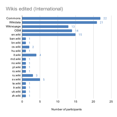
- 84 participants from 20 different wikis (who answered at least one question)
German-language survey
- Target group: future Kartographer users
- Goal: understand expectations and community prioritization of features
- 132 participants (who answered at least one question)
Almost 70% of participants in both surveys were long-time editors (9+ years).
Experience and Expectations from Kartographer of German wikis users (German-language survey)
[edit]- Many people do not know how Kartographer works
- Many contributors want to use Kartographer to do the things that it already does (add interactive maps which can pull geoshapes from OSM and which users can customize)
- Two clear groups emerged: those who want to make complex maps and those who make simple ones
- ~ ⅓ of participants don’t know much but are still excited to try Kartographer when it’s available, many as first time maps contributors
Existing problems that were mentioned the most (international survey)
[edit]
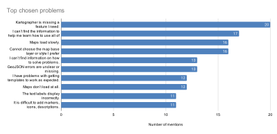
- There are a lot of problems related to how maps are displayed
- The existing documentation is not very helpful (both for learning and troubleshooting)
- Errors are confusing or nonexistent
- Complex maps are difficult to make
- Slow- or non-loading maps is a frequent and serious problem, not an edge case
- Some problems with multi-language labels persist, despite previous work by the WMF in 2018
Community prioritization of features (German-language and international survey)
[edit]
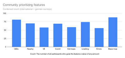
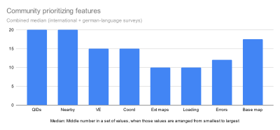
From previous research, the Technical Wishes team had identified some features with high potential impact for Kartographer. The team will likely have time to implement some improvements to Kartographer. Participants were asked which of these features they think the team should work on. Each participant was asked to distribute 100 points (all 100 points to one feature or split the amount between many features).
QIDs: Use QIDs from Wikidata to add markers to a map (similar to what is currently possible for geoshapes)
Nearby: Show other articles on the map (similar to “Places” tab in the iOS app but would have the option to show or hide)
VE: Update the VisualEditor maps interface so that users can access all the features that are currently available only in wikitext
Coord: Accept more coordinate formats than decimal only (e.g. 53° 30' 30.78")
Ext maps: Enable wikis to customize the list of external maps (photo example) shown to readers
Loading: Add visual feedback to show when maps are loading for complex maps and slow internet connections
Errors: Create better error messages for GeoJSON and broken maps
Base map: Add more options for map styles and overlays (e.g. could include mountain contours or bike paths)
Results
[edit]
- Top priorities: Showing nearby articles and using QIDs to add a geopoint (adding a marker to a coordinate on a map)
- Smaller features like loading indicators and external map service lists are lower priority but have widespread interest across user groups
- There is more interest in improving the editing process than in improving the reading experience for maps.
- There is a lot of interest in adding other base maps, styles, and data layers but free response fields show a lot of variation in what users want.
- Priorities differed between various sub-groupings, e.g.
- new vs. long-term editors
- more or less maps editing experience
- Wikivoyage editors vs. others
- German wikis vs. other language versions
Examples for different priorities:
- German Wikipedia editors have extra interest in base maps and show nearby, and less in errors.
- Experienced Kartographer users have higher interest in error message support.
- Both newer editors and those with less maps experience have a higher interest in improving the VisualEditor maps interface than long-term editors (6+ years) and those with more maps experience.
- Wikivoyage editors have a couple areas of significantly greater interest, esp. accepting more coordinate formats, customizing external map linking, and error messages.
- Whether participants are active on Wikivoyage and already have Kartographer editing experience seem to have the greatest influence on how they prioritize the features
Next steps
[edit]We have until the end of 2022 to work on the focus area “Better support for geoinformation”. We are currently prioritizing which of the features we can implement and which bugs we can fix in that timeframe based on
- impact on target groups
- implementation difficulty/risk
In the implementation we are planning to
- Work through features starting at top priorities
- Investigations and prototyping as needed to understand problems technically and explore designs
- Usability testing as needed throughout
Once we have identified a project that we feel confident we can finish, you will find it on our project page. On that page, we will also make transparent which features and bugs we’re investigating.
